Kīratpur geodata
Kīratpur (Uttar Pradesh) is a populated place; located in India in Asia/Kolkata (GMT+5.5) time zone. With population of 60,223 people, there are 728 cities with bigger population in this country. Compared to other cities in India, 91.1% of cities are located further ↓South; 51.2% of cities are located further ←West and 60.7% of cities have lower elevation than Kīratpur. Note1


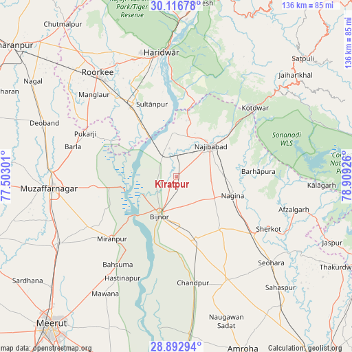
Kīratpur GPS coordinates[2]
29° 30' 24.156" North, 78° 12' 22.068" East
| Map corner | latitude | longitude |
|---|---|---|
| Upper-left | 30.11678°, | 77.50301° |
| Center: | 29.50671°, | 78.20613° |
| Lower-right: | 28.89294°, | 78.90926° |
| Map W x H: | 136.1×136.1 km | = 84.6×84.6mi |
| max Lat: | 34.9274° ⇑8.9% North |
| Kīratpur: | 29.50671° |
| min Lat: | ⇓91.1% South 8.09008° |
| min Long | Kīratpur | max Long |
| 68.82655° | 78.20613° | 96.81° |
| W 51.2%⇐ | ⇒48.8% E |
Elevation
Elevation of Kīratpur is 256 m = 840 ft, and this is 39.6 m = 130 ft below average elevation for this country.
| Max E: |
3681 m = 12077 ft | 39.3% |
| Avg. | 295.6 m = 970 ft | |
| Kīratpur | 256 m = 840 ft | |
Min E: |
1 m = 3 ft | 60.7% |
See also: Kīratpur elevation on elevation.city.
Geographical zone
Kīratpur is located in North temperate zone (between Tropic of Cancer and the Arctic Circle). Distance of this Northern Tropic circle is 674.9 km =419.4 mi to South.| Distance of | km | miles | from Kīratpur |
|---|---|---|---|
| North Pole | 6726.2 | 4179.5 | to North |
| Arctic Circle | 4120.3 | 2560.2 | to North |
| Tropic Cancer | 674.9 | 419.4 | to South |
| Equator | 3280.8 | 2038.6 | to South |


Nearby cities:
15 places around Kīratpur: (largest is in red/bold)
• Bahsūma
40.9 km =25.4 mi,  213°
213°
• Bijnor
16.3 km =10.1 mi,  204°
204°
• Dhāmpur
36.8 km =22.9 mi,  126°
126°
• Haldaur
25.3 km =15.7 mi,  162°
162°
• Jhālu
19.1 km =11.9 mi,  174°
174°
• Jānsath
39.9 km =24.8 mi,  239°
239°
• Kotdwāra
40.5 km =25.2 mi,  48°
48°
• Laksar
32.2 km =20 mi,  330°
330°
• Mandāwar
7.9 km =4.9 mi,  253°
253°
• Mīrānpur
34.6 km =21.5 mi,  225°
225°
• Nagīna
23.3 km =14.5 mi,  107°
107°
• Najībābād
17.6 km =10.9 mi, 48°
• Nihtaur
26.8 km =16.7 mi,  139°
139°
• Sherkot
40.9 km =25.4 mi,  119°
119°
• Sultānpur
29.2 km =18.1 mi,  341°
341°
Sources, notices
• [Note1] Compared only with cities in India existing in our database
• [Src1] Map data: © OpenStreetMap contributors (CC-BY-SA)
• [Src2] Other city data from geonames.org with taken over terms of usage.
• [Src3] Geographical zone / Annual Mean Temperature by Robert A. Rohde @ Wikipedia
