Mihona geodata
Mihona (Madhya Pradesh) is a populated place; located in India in Asia/Kolkata (GMT+5.5) time zone. With population of 15,830 people, there are 2386 cities with bigger population in this country. Compared to other cities in India, 72.9% of cities are located further ↓South; 58.8% of cities are located further ←West and 59.3% of cities have higher elevation than Mihona. Note1


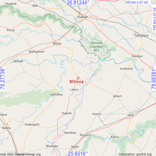
Mihona GPS coordinates[2]
26° 17' 1.428" North, 78° 58' 49.728" East
| Map corner | latitude | longitude |
|---|---|---|
| Upper-left | 26.91244°, | 78.27736° |
| Center: | 26.28373°, | 78.98048° |
| Lower-right: | 25.6516°, | 79.68361° |
| Map W x H: | 140.2×140.2 km | = 87.1×87.1mi |
| max Lat: | 34.9274° ⇑27.1% North |
| Mihona: | 26.28373° |
| min Lat: | ⇓72.9% South 8.09008° |
| min Long | Mihona | max Long |
| 68.82655° | 78.98048° | 96.81° |
| W 58.8%⇐ | ⇒41.2% E |
Elevation
Elevation of Mihona is 152 m = 499 ft, and this is 143.6 m = 471 ft below average elevation for this country.
| Max E: |
3681 m = 12077 ft | 59.3% |
| Avg. | 295.6 m = 970 ft | |
| Mihona | 152 m = 499 ft | |
Min E: |
1 m = 3 ft | 40.7% |
See also: India elevation on elevation.city.
Geographical zone
Mihona is located in North temperate zone (between Tropic of Cancer and the Arctic Circle). Distance of this Northern Tropic circle is 316.6 km =196.7 mi to South.| Distance of | km | miles | from Mihona |
|---|---|---|---|
| North Pole | 7084.6 | 4402.2 | to North |
| Arctic Circle | 4478.7 | 2782.9 | to North |
| Tropic Cancer | 316.6 | 196.7 | to South |
| Equator | 2922.5 | 1816 | to South |


Nearby cities:
15 places around Mihona: (largest is in red/bold)
• Alampur
34.1 km =21.2 mi,  212°
212°
• Bakewar
46.4 km =28.8 mi,  24°
24°
• Bhind
36.9 km =22.9 mi,  328°
328°
• Daboh
33 km =20.5 mi,  198°
198°
• Jālaun
38.7 km =24 mi,  113°
113°
• Konch
36.4 km =22.6 mi,  152°
152°
• Lahār
10.7 km =6.6 mi, 201°
• Lakhnā
43.8 km =27.2 mi, 22°
• Mahgawān
43.2 km =26.8 mi,  302°
302°
• Mau
30.9 km =19.2 mi,  266°
266°
• Mādhogarh
20.5 km =12.7 mi,  92°
92°
• Nadīgaon
20 km =12.4 mi,  167°
167°
• Rāmpura
21.4 km =13.3 mi,  69°
69°
• Seondha
24.5 km =15.2 mi,  234°
234°
• Umri
25.6 km =15.9 mi,  350°
350°
Sources, notices
• [Note1] Compared only with cities in India existing in our database
• [Src1] Map data: © OpenStreetMap contributors (CC-BY-SA)
• [Src2] Other city data from geonames.org with taken over terms of usage.
• [Src3] Geographical zone / Annual Mean Temperature by Robert A. Rohde @ Wikipedia
