Mungeli geodata
Mungeli (Chhattisgarh) is a seat of a second-order administrative division; located in India in Asia/Kolkata (GMT+5.5) time zone. With population of 27,698 people, there are 1558 cities with bigger population in this country. Compared to other cities in India, 56.3% of cities are located further ↑North; 75.4% of cities are located further ←West and 65.2% of cities have lower elevation than Mungeli. Note1


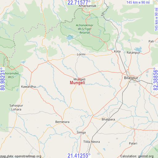
Mungeli GPS coordinates[2]
22° 3' 56.376" North, 81° 41' 7.548" East
| Map corner | latitude | longitude |
|---|---|---|
| Upper-left | 22.71577°, | 80.98231° |
| Center: | 22.06566°, | 81.68543° |
| Lower-right: | 21.41255°, | 82.38856° |
| Map W x H: | 144.9×144.9 km | = 90×90mi |
| max Lat: | 34.9274° ⇑56.3% North |
| Mungeli: | 22.06566° |
| min Lat: | ⇓43.7% South 8.09008° |
| min Long | Mungeli | max Long |
| 68.82655° | 81.68543° | 96.81° |
| W 75.4%⇐ | ⇒24.6% E |
Elevation
Elevation of Mungeli is 287 m = 942 ft, and this is 8.6 m = 28 ft below average elevation for this country.
| Max E: |
3681 m = 12077 ft | 34.8% |
| Avg. | 295.6 m = 970 ft | |
| Mungeli | 287 m = 942 ft | |
Min E: |
1 m = 3 ft | 65.2% |
See also: India elevation on elevation.city.
Geographical zone
Mungeli is located in North Torrid zone (between Equator and Tropic of Cancer). Distance of this Northern Tropic circle is 152.4 km =94.7 mi to North.| Distance of | km | miles | from Mungeli |
|---|---|---|---|
| North Pole | 7553.6 | 4693.6 | to North |
| Arctic Circle | 4947.7 | 3074.4 | to North |
| Tropic Cancer | 152.4 | 94.7 | to North |
| Equator | 2453.5 | 1524.5 | to South |


Nearby cities:
15 places around Mungeli: (largest is in red/bold)
• Akaltara
76.5 km =47.5 mi,  93°
93°
• Amarkantak
68.2 km =42.4 mi,  6°
6°
• Baloda Bāzār
66.9 km =41.6 mi,  132°
132°
• Bemetāra
41.9 km =26 mi,  201°
201°
• Bhātāpāra
45.6 km =28.3 mi,  143°
143°
• Bilāspur
48.5 km =30.1 mi, 88°
• Gandai
74.9 km =46.5 mi,  233°
233°
• Kawardha
47.2 km =29.3 mi,  262°
262°
• Kotā
43.2 km =26.8 mi,  53°
53°
• Lormi
23.3 km =14.5 mi,  4°
4°
• Pandaria
33.4 km =20.8 mi,  301°
301°
• Pāndātarai
39.2 km =24.4 mi,  290°
290°
• Ratanpur
55.5 km =34.5 mi,  63°
63°
• Simga
48.7 km =30.3 mi,  177°
177°
• Takhatpur
20.2 km =12.6 mi,  69°
69°
Sources, notices
• [Note1] Compared only with cities in India existing in our database
• [Src1] Map data: © OpenStreetMap contributors (CC-BY-SA)
• [Src2] Other city data from geonames.org with taken over terms of usage.
• [Src3] Geographical zone / Annual Mean Temperature by Robert A. Rohde @ Wikipedia
