Bilāspur geodata
Bilāspur (Chhattisgarh) is a populated place; located in India in Asia/Kolkata (GMT+5.5) time zone. With population of 282,705 people, there are 156 cities with bigger population in this country. Compared to other cities in India, 56.2% of cities are located further ↑North; 77.1% of cities are located further ←West and 62.1% of cities have lower elevation than Bilāspur. Note1


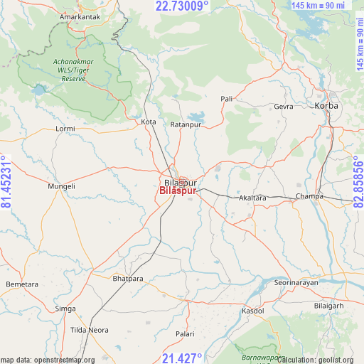
Bilāspur GPS coordinates[2]
22° 4' 48.18" North, 82° 9' 19.548" East
| Map corner | latitude | longitude |
|---|---|---|
| Upper-left | 22.73009°, | 81.45231° |
| Center: | 22.08005°, | 82.15543° |
| Lower-right: | 21.427°, | 82.85856° |
| Map W x H: | 144.9×144.9 km | = 90×90mi |
| max Lat: | 34.9274° ⇑56.2% North |
| Bilāspur: | 22.08005° |
| min Lat: | ⇓43.8% South 8.09008° |
| min Long | Bilāspur | max Long |
| 68.82655° | 82.15543° | 96.81° |
| W 77.1%⇐ | ⇒22.9% E |
Elevation
Elevation of Bilāspur is 265 m = 869 ft, and this is 30.6 m = 100 ft below average elevation for this country.
| Max E: |
3681 m = 12077 ft | 37.9% |
| Avg. | 295.6 m = 970 ft | |
| Bilāspur | 265 m = 869 ft | |
Min E: |
1 m = 3 ft | 62.1% |
See also: Bilāspur elevation on elevation.city.
Geographical zone
Bilāspur is located in North Torrid zone (between Equator and Tropic of Cancer). Distance of this Northern Tropic circle is 150.8 km =93.7 mi to North.| Distance of | km | miles | from Bilāspur |
|---|---|---|---|
| North Pole | 7552 | 4692.6 | to North |
| Arctic Circle | 4946.1 | 3073.4 | to North |
| Tropic Cancer | 150.8 | 93.7 | to North |
| Equator | 2455.1 | 1525.5 | to South |


Nearby cities:
15 places around Bilāspur: (largest is in red/bold)
• Akaltara
28.6 km =17.8 mi,  102°
102°
• Baloda
34.2 km =21.3 mi,  78°
78°
• Baloda Bāzār
47.1 km =29.3 mi,  179°
179°
• Bhātāpāra
44 km =27.3 mi,  209°
209°
• Chāmpa
50.4 km =31.3 mi, 95°
• Jānjgīr
44.2 km =27.5 mi, 100°
• Katghora
61.6 km =38.3 mi,  40°
40°
• Kharod
57.5 km =35.7 mi,  130°
130°
• Korba
63 km =39.1 mi,  62°
62°
• Kotā
27.5 km =17.1 mi,  330°
330°
• Lormi
51.5 km =32 mi,  294°
294°
• Mungeli
48.5 km =30.1 mi,  268°
268°
• Ratanpur
23 km =14.3 mi,  3°
3°
• Seorīnārāyan
60.3 km =37.5 mi, 131°
• Takhatpur
29.9 km =18.6 mi,  280°
280°
Sources, notices
• [Note1] Compared only with cities in India existing in our database
• [Src1] Map data: © OpenStreetMap contributors (CC-BY-SA)
• [Src2] Other city data from geonames.org with taken over terms of usage.
• [Src3] Geographical zone / Annual Mean Temperature by Robert A. Rohde @ Wikipedia
