Kotā geodata
Kotā (Chhattisgarh) is a populated place; located in India in Asia/Kolkata (GMT+5.5) time zone. With population of 15,582 people, there are 2409 cities with bigger population in this country. Compared to other cities in India, 54.6% of cities are located further ↑North; 76.7% of cities are located further ←West and 70.6% of cities have lower elevation than Kotā. Note1


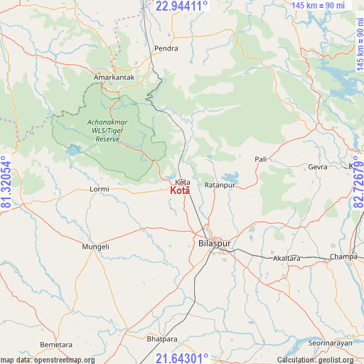
Kotā GPS coordinates[2]
22° 17' 42.252" North, 82° 1' 25.176" East
| Map corner | latitude | longitude |
|---|---|---|
| Upper-left | 22.94411°, | 81.32054° |
| Center: | 22.29507°, | 82.02366° |
| Lower-right: | 21.64301°, | 82.72679° |
| Map W x H: | 144.7×144.7 km | = 89.9×89.9mi |
| max Lat: | 34.9274° ⇑54.6% North |
| Kotā: | 22.29507° |
| min Lat: | ⇓45.4% South 8.09008° |
| min Long | Kotā | max Long |
| 68.82655° | 82.02366° | 96.81° |
| W 76.7%⇐ | ⇒23.3% E |
Elevation
Elevation of Kotā is 333 m = 1093 ft, and this is 37.4 m = 123 ft above average elevation for this country.
| Max E: |
3681 m = 12077 ft | 29.4% |
| Kotā | 333 m 1093 ft | |
| Avg. | 295.6 m = 970 ft | |
Min E: |
1 m = 3 ft | 70.6% |
See also: India elevation on elevation.city.
Geographical zone
Kotā is located in North Torrid zone (between Equator and Tropic of Cancer). Distance of this Northern Tropic circle is 126.9 km =78.9 mi to North.| Distance of | km | miles | from Kotā |
|---|---|---|---|
| North Pole | 7528.1 | 4677.7 | to North |
| Arctic Circle | 4922.2 | 3058.5 | to North |
| Tropic Cancer | 126.9 | 78.9 | to North |
| Equator | 2479 | 1540.4 | to South |


Nearby cities:
15 places around Kotā: (largest is in red/bold)
• Akaltara
51.2 km =31.8 mi,  125°
125°
• Amarkantak
50.2 km =31.2 mi,  327°
327°
• Baloda
50.2 km =31.2 mi,  110°
110°
• Bhātāpāra
62.8 km =39 mi,  187°
187°
• Bilāspur
27.5 km =17.1 mi,  150°
150°
• Gaurela
52.6 km =32.7 mi,  346°
346°
• Jānjgīr
65.3 km =40.6 mi,  119°
119°
• Katghora
58.1 km =36.1 mi,  66°
66°
• Lormi
33.2 km =20.6 mi,  266°
266°
• Mungeli
43.2 km =26.8 mi,  233°
233°
• Pandaria
63.6 km =39.5 mi,  262°
262°
• Pasān
63.6 km =39.5 mi,  16°
16°
• Pendra
53.8 km =33.4 mi, 352°
• Ratanpur
14.9 km =9.3 mi,  93°
93°
• Takhatpur
24.3 km =15.1 mi,  220°
220°
Sources, notices
• [Note1] Compared only with cities in India existing in our database
• [Src1] Map data: © OpenStreetMap contributors (CC-BY-SA)
• [Src2] Other city data from geonames.org with taken over terms of usage.
• [Src3] Geographical zone / Annual Mean Temperature by Robert A. Rohde @ Wikipedia
