Baloda Bāzār geodata
Baloda Bāzār (Chhattisgarh) is a seat of a second-order administrative division; located in India in Asia/Kolkata (GMT+5.5) time zone. With population of 25,235 people, there are 1687 cities with bigger population in this country. Compared to other cities in India, 58.3% of cities are located further ↑North; 77.1% of cities are located further ←West and 61.2% of cities have lower elevation than Baloda Bāzār. Note1


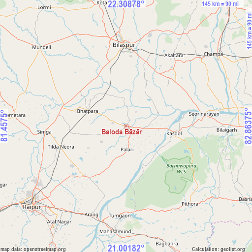
Baloda Bāzār GPS coordinates[2]
21° 39' 24.408" North, 82° 9' 38.232" East
| Map corner | latitude | longitude |
|---|---|---|
| Upper-left | 22.30878°, | 81.4575° |
| Center: | 21.65678°, | 82.16062° |
| Lower-right: | 21.00182°, | 82.86375° |
| Map W x H: | 145.3×145.3 km | = 90.3×90.3mi |
| max Lat: | 34.9274° ⇑58.3% North |
| Baloda Bāzār: | 21.65678° |
| min Lat: | ⇓41.7% South 8.09008° |
| min Long | Baloda Bāzār | max Long |
| 68.82655° | 82.16062° | 96.81° |
| W 77.1%⇐ | ⇒22.9% E |
Elevation
Elevation of Baloda Bāzār is 259 m = 850 ft, and this is 36.6 m = 120 ft below average elevation for this country.
| Max E: |
3681 m = 12077 ft | 38.8% |
| Avg. | 295.6 m = 970 ft | |
| Baloda Bāzār | 259 m = 850 ft | |
Min E: |
1 m = 3 ft | 61.2% |
See also: India elevation on elevation.city.
Geographical zone
Baloda Bāzār is located in North Torrid zone (between Equator and Tropic of Cancer). Distance of this Northern Tropic circle is 197.9 km =123 mi to North.| Distance of | km | miles | from Baloda Bāzār |
|---|---|---|---|
| North Pole | 7599.1 | 4721.9 | to North |
| Arctic Circle | 4993.2 | 3102.6 | to North |
| Tropic Cancer | 197.9 | 123 | to North |
| Equator | 2408 | 1496.3 | to South |


Nearby cities:
15 places around Baloda Bāzār: (largest is in red/bold)
• Akaltara
49.2 km =30.6 mi,  33°
33°
• Arang
54.9 km =34.1 mi,  201°
201°
• Baloda
63 km =39.1 mi, 31°
• Bemetāra
65 km =40.4 mi,  275°
275°
• Bhātāpāra
23.7 km =14.7 mi,  291°
291°
• Bilāspur
47.1 km =29.3 mi,  359°
359°
• Chāmpa
65.1 km =40.5 mi,  49°
49°
• Deori
52.5 km =32.6 mi,  115°
115°
• Jānjgīr
58.2 km =36.2 mi, 47°
• Kharod
44.3 km =27.5 mi,  77°
77°
• Mahāsamund
61.5 km =38.2 mi,  186°
186°
• Pithora
58.3 km =36.2 mi,  140°
140°
• Seorīnārāyan
45.3 km =28.1 mi, 80°
• Simga
47.3 km =29.4 mi,  266°
266°
• Takhatpur
60.5 km =37.6 mi,  330°
330°
Sources, notices
• [Note1] Compared only with cities in India existing in our database
• [Src1] Map data: © OpenStreetMap contributors (CC-BY-SA)
• [Src2] Other city data from geonames.org with taken over terms of usage.
• [Src3] Geographical zone / Annual Mean Temperature by Robert A. Rohde @ Wikipedia
