Amarkantak geodata
Amarkantak (Madhya Pradesh) is a populated place; located in India in Asia/Kolkata (GMT+5.5) time zone. With population of 7,613 people, there are 3160 cities with bigger population in this country. Compared to other cities in India, 51.3% of cities are located further ↑North; 75.8% of cities are located further ←West and 96.4% of cities have lower elevation than Amarkantak. Note1


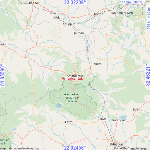
Amarkantak GPS coordinates[2]
22° 40' 29.496" North, 81° 45' 32.688" East
| Map corner | latitude | longitude |
|---|---|---|
| Upper-left | 23.32209°, | 81.05596° |
| Center: | 22.67486°, | 81.75908° |
| Lower-right: | 22.02456°, | 82.46221° |
| Map W x H: | 144.3×144.3 km | = 89.7×89.7mi |
| max Lat: | 34.9274° ⇑51.3% North |
| Amarkantak: | 22.67486° |
| min Lat: | ⇓48.7% South 8.09008° |
| min Long | Amarkantak | max Long |
| 68.82655° | 81.75908° | 96.81° |
| W 75.8%⇐ | ⇒24.2% E |
Elevation
Elevation of Amarkantak is 1042 m = 3419 ft, and this is 746.4 m = 2449 ft above average elevation for this country.
| Max E: |
3681 m = 12077 ft | 3.6% |
| Amarkantak | 1042 m 3419 ft | |
| Avg. | 295.6 m = 970 ft | |
Min E: |
1 m = 3 ft | 96.4% |
See also: India elevation on elevation.city.
Geographical zone
Amarkantak is located in North Torrid zone (between Equator and Tropic of Cancer). Distance of this Northern Tropic circle is 84.7 km =52.6 mi to North.| Distance of | km | miles | from Amarkantak |
|---|---|---|---|
| North Pole | 7485.9 | 4651.5 | to North |
| Arctic Circle | 4880 | 3032.3 | to North |
| Tropic Cancer | 84.7 | 52.6 | to North |
| Equator | 2521.2 | 1566.6 | to South |


Nearby cities:
15 places around Amarkantak: (largest is in red/bold)
• Anūppur
48.2 km =30 mi,  351°
351°
• Bodri
64 km =39.8 mi,  328°
328°
• Burhar
64.4 km =40 mi,  338°
338°
• Dindori
75.7 km =47 mi,  293°
293°
• Gaurela
17 km =10.6 mi,  58°
58°
• Kotma
63 km =39.1 mi,  20°
20°
• Kotā
50.2 km =31.2 mi,  147°
147°
• Lormi
44.9 km =27.9 mi,  187°
187°
• Mungeli
68.2 km =42.4 mi, 186°
• Pandaria
61.6 km =38.3 mi,  215°
215°
• Pasān
48.8 km =30.3 mi,  67°
67°
• Pendra
23.4 km =14.5 mi, 61°
• Pāndātarai
70 km =43.5 mi, 219°
• Ratanpur
60.3 km =37.5 mi,  135°
135°
• Takhatpur
61.7 km =38.3 mi,  169°
169°
Sources, notices
• [Note1] Compared only with cities in India existing in our database
• [Src1] Map data: © OpenStreetMap contributors (CC-BY-SA)
• [Src2] Other city data from geonames.org with taken over terms of usage.
• [Src3] Geographical zone / Annual Mean Temperature by Robert A. Rohde @ Wikipedia
