Bhadaur geodata
Bhadaur (Punjab) is a populated place; located in India in Asia/Kolkata (GMT+5.5) time zone. With population of 17,532 people, there are 2234 cities with bigger population in this country. Compared to other cities in India, 94.3% of cities are located further ↓South; 80% of cities are located further →East and 56.1% of cities have lower elevation than Bhadaur. Note1


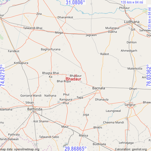
Bhadaur GPS coordinates[2]
30° 28' 35.436" North, 75° 19' 49.764" East
| Map corner | latitude | longitude |
|---|---|---|
| Upper-left | 31.0806°, | 74.62737° |
| Center: | 30.47651°, | 75.33049° |
| Lower-right: | 29.86865°, | 76.03362° |
| Map W x H: | 134.8×134.8 km | = 83.8×83.8mi |
| max Lat: | 34.9274° ⇑5.7% North |
| Bhadaur: | 30.47651° |
| min Lat: | ⇓94.3% South 8.09008° |
| min Long | Bhadaur | max Long |
| 68.82655° | 75.33049° | 96.81° |
| W 20%⇐ | ⇒80% E |
Elevation
Elevation of Bhadaur is 230 m = 755 ft, and this is 65.6 m = 215 ft below average elevation for this country.
| Max E: |
3681 m = 12077 ft | 43.9% |
| Avg. | 295.6 m = 970 ft | |
| Bhadaur | 230 m = 755 ft | |
Min E: |
1 m = 3 ft | 56.1% |
See also: India elevation on elevation.city.
Geographical zone
Bhadaur is located in North temperate zone (between Tropic of Cancer and the Arctic Circle). Distance of this Northern Tropic circle is 782.8 km =486.4 mi to South.| Distance of | km | miles | from Bhadaur |
|---|---|---|---|
| North Pole | 6618.4 | 4112.5 | to North |
| Arctic Circle | 4012.5 | 2493.3 | to North |
| Tropic Cancer | 782.8 | 486.4 | to South |
| Equator | 3388.7 | 2105.6 | to South |


Nearby cities:
15 places around Bhadaur: (largest is in red/bold)
• Badhni Kalān
23.1 km =14.4 mi,  350°
350°
• Barnāla
23.8 km =14.8 mi,  118°
118°
• Bathinda
48 km =29.8 mi,  231°
231°
• Bhīkhi
50.4 km =31.3 mi,  157°
157°
• Bāgha Purāna
32.4 km =20.1 mi,  316°
316°
• Dhanaula
31.8 km =19.8 mi,  132°
132°
• Jagraon
37.2 km =23.1 mi,  21°
21°
• Jaito
42.1 km =26.2 mi,  266°
266°
• Kotkapura
49.1 km =30.5 mi,  283°
283°
• Laungowāl
46 km =28.6 mi, 133°
• Maur
44.4 km =27.6 mi,  190°
190°
• Moga
40.6 km =25.2 mi,  337°
337°
• Māler Kotla
52.9 km =32.9 mi,  83°
83°
• Rāikot
32.2 km =20 mi,  53°
53°
• Rāmpura
26 km =16.2 mi,  199°
199°
Sources, notices
• [Note1] Compared only with cities in India existing in our database
• [Src1] Map data: © OpenStreetMap contributors (CC-BY-SA)
• [Src2] Other city data from geonames.org with taken over terms of usage.
• [Src3] Geographical zone / Annual Mean Temperature by Robert A. Rohde @ Wikipedia
