Sirsā geodata
Sirsā (Uttar Pradesh) is a populated place; located in India in Asia/Kolkata (GMT+5.5) time zone. With population of 12,608 people, there are 2692 cities with bigger population in this country. Compared to other cities in India, 64.9% of cities are located further ↓South; 76.8% of cities are located further ←West and 69.3% of cities have higher elevation than Sirsā. Note1


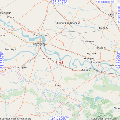
Sirsā GPS coordinates[2]
25° 15' 48.24" North, 82° 5' 30.84" East
| Map corner | latitude | longitude |
|---|---|---|
| Upper-left | 25.8976°, | 81.38878° |
| Center: | 25.2634°, | 82.0919° |
| Lower-right: | 24.62587°, | 82.79503° |
| Map W x H: | 141.4×141.4 km | = 87.9×87.9mi |
| max Lat: | 34.9274° ⇑35.1% North |
| Sirsā: | 25.2634° |
| min Lat: | ⇓64.9% South 8.09008° |
| min Long | Sirsā | max Long |
| 68.82655° | 82.0919° | 96.81° |
| W 76.8%⇐ | ⇒23.2% E |
Elevation
Elevation of Sirsā is 96 m = 315 ft, and this is 199.6 m = 655 ft below average elevation for this country.
| Max E: |
3681 m = 12077 ft | 69.3% |
| Avg. | 295.6 m = 970 ft | |
| Sirsā | 96 m = 315 ft | |
Min E: |
1 m = 3 ft | 30.7% |
See also: India elevation on elevation.city.
Geographical zone
Sirsā is located in North temperate zone (between Tropic of Cancer and the Arctic Circle). Distance of this Northern Tropic circle is 203.1 km =126.2 mi to South.| Distance of | km | miles | from Sirsā |
|---|---|---|---|
| North Pole | 7198 | 4472.6 | to North |
| Arctic Circle | 4592.1 | 2853.4 | to North |
| Tropic Cancer | 203.1 | 126.2 | to South |
| Equator | 2809 | 1745.4 | to South |


Nearby cities:
15 places around Sirsā: (largest is in red/bold)
• Allahābād
32.1 km =19.9 mi,  308°
308°
• Bhadohi
50.3 km =31.3 mi,  73°
73°
• Chail
49.6 km =30.8 mi,  291°
291°
• Gyānpur
38.4 km =23.9 mi,  78°
78°
• Handiā
14.7 km =9.1 mi,  40°
40°
• Jhūsi
26.9 km =16.7 mi,  315°
315°
• Machhlīshahr
56.8 km =35.3 mi,  34°
34°
• Mau Aimma
50.9 km =31.6 mi,  340°
340°
• Mirzāpur
49.4 km =30.7 mi,  105°
105°
• Phulpur
31.8 km =19.8 mi,  359°
359°
• Sarāi Ākil
59.8 km =37.2 mi,  282°
282°
• Shankargarh
48.6 km =30.2 mi,  259°
259°
• Sohāgi
50.7 km =31.5 mi,  231°
231°
• Suriānwān
39.7 km =24.7 mi,  55°
55°
• Teonthar
55 km =34.2 mi,  235°
235°
Sources, notices
• [Note1] Compared only with cities in India existing in our database
• [Src1] Map data: © OpenStreetMap contributors (CC-BY-SA)
• [Src2] Other city data from geonames.org with taken over terms of usage.
• [Src3] Geographical zone / Annual Mean Temperature by Robert A. Rohde @ Wikipedia
