Kabrāi geodata
Kabrāi (Uttar Pradesh) is a populated place; located in India in Asia/Kolkata (GMT+5.5) time zone. With population of 24,771 people, there are 1718 cities with bigger population in this country. Compared to other cities in India, 66% of cities are located further ↓South; 67.8% of cities are located further ←West and 56.7% of cities have higher elevation than Kabrāi. Note1


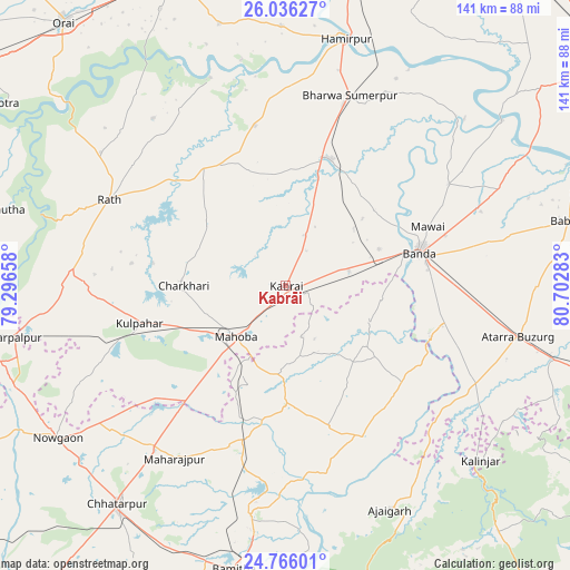
Kabrāi GPS coordinates[2]
25° 24' 10.116" North, 79° 59' 58.92" East
| Map corner | latitude | longitude |
|---|---|---|
| Upper-left | 26.03627°, | 79.29658° |
| Center: | 25.40281°, | 79.9997° |
| Lower-right: | 24.76601°, | 80.70283° |
| Map W x H: | 141.2×141.2 km | = 87.7×87.7mi |
| max Lat: | 34.9274° ⇑34% North |
| Kabrāi: | 25.40281° |
| min Lat: | ⇓66% South 8.09008° |
| min Long | Kabrāi | max Long |
| 68.82655° | 79.9997° | 96.81° |
| W 67.8%⇐ | ⇒32.2% E |
Elevation
Elevation of Kabrāi is 166 m = 545 ft, and this is 129.6 m = 425 ft below average elevation for this country.
| Max E: |
3681 m = 12077 ft | 56.7% |
| Avg. | 295.6 m = 970 ft | |
| Kabrāi | 166 m = 545 ft | |
Min E: |
1 m = 3 ft | 43.3% |
See also: India elevation on elevation.city.
Geographical zone
Kabrāi is located in North temperate zone (between Tropic of Cancer and the Arctic Circle). Distance of this Northern Tropic circle is 218.6 km =135.8 mi to South.| Distance of | km | miles | from Kabrāi |
|---|---|---|---|
| North Pole | 7182.5 | 4463 | to North |
| Arctic Circle | 4576.6 | 2843.8 | to North |
| Tropic Cancer | 218.6 | 135.8 | to South |
| Equator | 2824.5 | 1755.1 | to South |


Nearby cities:
15 places around Kabrāi: (largest is in red/bold)
• Atarra
58.9 km =36.6 mi,  102°
102°
• Bānda
34.7 km =21.6 mi,  76°
76°
• Chandla
41.7 km =25.9 mi,  152°
152°
• Charkhāri
25.2 km =15.7 mi,  270°
270°
• Gohānd
56.2 km =34.9 mi,  305°
305°
• Kharela
24.4 km =15.2 mi, 309°
• Kulpahār
37.4 km =23.2 mi,  255°
255°
• Mahobā
17.7 km =11 mi,  225°
225°
• Mataundh
16.2 km =10.1 mi, 76°
• Maudaha
33.2 km =20.6 mi,  20°
20°
• Naraini
53.3 km =33.1 mi,  116°
116°
• Rājnagar
57.8 km =35.9 mi,  188°
188°
• Rāth
48.4 km =30.1 mi,  296°
296°
• Sarīla
52.7 km =32.7 mi,  321°
321°
• Tindwāri
58.1 km =36.1 mi,  65°
65°
Sources, notices
• [Note1] Compared only with cities in India existing in our database
• [Src1] Map data: © OpenStreetMap contributors (CC-BY-SA)
• [Src2] Other city data from geonames.org with taken over terms of usage.
• [Src3] Geographical zone / Annual Mean Temperature by Robert A. Rohde @ Wikipedia
