Mahobā geodata
Mahobā (Uttar Pradesh) is a populated place; located in India in Asia/Kolkata (GMT+5.5) time zone. With population of 89,170 people, there are 502 cities with bigger population in this country. Compared to other cities in India, 65.1% of cities are located further ↓South; 66.9% of cities are located further ←West and 51.1% of cities have lower elevation than Mahobā. Note1


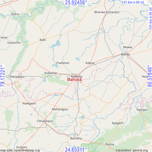
Mahobā GPS coordinates[2]
25° 17' 25.8" North, 79° 52' 31.188" East
| Map corner | latitude | longitude |
|---|---|---|
| Upper-left | 25.92456°, | 79.17221° |
| Center: | 25.2905°, | 79.87533° |
| Lower-right: | 24.65311°, | 80.57846° |
| Map W x H: | 141.4×141.4 km | = 87.9×87.9mi |
| max Lat: | 34.9274° ⇑34.9% North |
| Mahobā: | 25.2905° |
| min Lat: | ⇓65.1% South 8.09008° |
| min Long | Mahobā | max Long |
| 68.82655° | 79.87533° | 96.81° |
| W 66.9%⇐ | ⇒33.1% E |
Elevation
Elevation of Mahobā is 208 m = 682 ft, and this is 87.6 m = 287 ft below average elevation for this country.
| Max E: |
3681 m = 12077 ft | 48.9% |
| Avg. | 295.6 m = 970 ft | |
| Mahobā | 208 m = 682 ft | |
Min E: |
1 m = 3 ft | 51.1% |
See also: Mahobā elevation on elevation.city.
Geographical zone
Mahobā is located in North temperate zone (between Tropic of Cancer and the Arctic Circle). Distance of this Northern Tropic circle is 206.1 km =128.1 mi to South.| Distance of | km | miles | from Mahobā |
|---|---|---|---|
| North Pole | 7195 | 4470.8 | to North |
| Arctic Circle | 4589.1 | 2851.5 | to North |
| Tropic Cancer | 206.1 | 128.1 | to South |
| Equator | 2812 | 1747.3 | to South |


Nearby cities:
15 places around Mahobā: (largest is in red/bold)
• Bānda
50.6 km =31.4 mi,  65°
65°
• Chandla
40.2 km =25 mi,  127°
127°
• Charkhāri
17.8 km =11.1 mi,  314°
314°
• Chhatarpur
50.5 km =31.4 mi,  214°
214°
• Gohānd
56.2 km =34.9 mi,  323°
323°
• Harpālpur
54.5 km =33.9 mi,  269°
269°
• Kabrāi
17.7 km =11 mi,  45°
45°
• Khajuraho Group of Monuments
49.5 km =30.8 mi,  173°
173°
• Kharela
28.8 km =17.9 mi,  347°
347°
• Kulpahār
24 km =14.9 mi,  277°
277°
• Mataundh
32.6 km =20.3 mi,  60°
60°
• Maudaha
49.8 km =30.9 mi,  28°
28°
• Rājnagar
44.8 km =27.8 mi,  175°
175°
• Rāth
45.9 km =28.5 mi, 317°
• Sarīla
57.6 km =35.8 mi,  339°
339°
Sources, notices
• [Note1] Compared only with cities in India existing in our database
• [Src1] Map data: © OpenStreetMap contributors (CC-BY-SA)
• [Src2] Other city data from geonames.org with taken over terms of usage.
• [Src3] Geographical zone / Annual Mean Temperature by Robert A. Rohde @ Wikipedia
