Phulpur geodata
Phulpur (Uttar Pradesh) is a populated place; located in India in Asia/Kolkata (GMT+5.5) time zone. With population of 22,886 people, there are 1841 cities with bigger population in this country. Compared to other cities in India, 67.2% of cities are located further ↓South; 76.8% of cities are located further ←West and 68.1% of cities have higher elevation than Phulpur. Note1


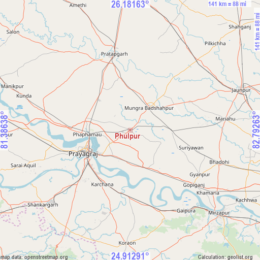
Phulpur GPS coordinates[2]
25° 32' 56.22" North, 82° 5' 22.2" East
| Map corner | latitude | longitude |
|---|---|---|
| Upper-left | 26.18163°, | 81.38638° |
| Center: | 25.54895°, | 82.0895° |
| Lower-right: | 24.91291°, | 82.79263° |
| Map W x H: | 141.1×141.1 km | = 87.7×87.7mi |
| max Lat: | 34.9274° ⇑32.8% North |
| Phulpur: | 25.54895° |
| min Lat: | ⇓67.2% South 8.09008° |
| min Long | Phulpur | max Long |
| 68.82655° | 82.0895° | 96.81° |
| W 76.8%⇐ | ⇒23.2% E |
Elevation
Elevation of Phulpur is 102 m = 335 ft, and this is 193.6 m = 635 ft below average elevation for this country.
| Max E: |
3681 m = 12077 ft | 68.1% |
| Avg. | 295.6 m = 970 ft | |
| Phulpur | 102 m = 335 ft | |
Min E: |
1 m = 3 ft | 31.9% |
See also: India elevation on elevation.city.
Geographical zone
Phulpur is located in North temperate zone (between Tropic of Cancer and the Arctic Circle). Distance of this Northern Tropic circle is 234.9 km =146 mi to South.| Distance of | km | miles | from Phulpur |
|---|---|---|---|
| North Pole | 7166.3 | 4452.9 | to North |
| Arctic Circle | 4560.4 | 2833.7 | to North |
| Tropic Cancer | 234.9 | 146 | to South |
| Equator | 2840.8 | 1765.2 | to South |


Nearby cities:
15 places around Phulpur: (largest is in red/bold)
• Allahābād
27.3 km =17 mi,  244°
244°
• Bela
42.4 km =26.3 mi,  347°
347°
• Bhadohi
51.2 km =31.8 mi,  109°
109°
• Chail
47.9 km =29.8 mi,  253°
253°
• Gyānpur
44.8 km =27.8 mi,  122°
122°
• Handiā
22.8 km =14.2 mi,  154°
154°
• Jhūsi
22.2 km =13.8 mi, 236°
• Lālganj
57.4 km =35.7 mi,  317°
317°
• Machhlīshahr
35.6 km =22.1 mi,  64°
64°
• Mariāhu
51.9 km =32.2 mi,  83°
83°
• Mau Aimma
23.3 km =14.5 mi,  314°
314°
• Patti
42.9 km =26.7 mi,  15°
15°
• Pratāpgarh
41.2 km =25.6 mi,  339°
339°
• Sirsā
31.8 km =19.8 mi,  179°
179°
• Suriānwān
34.4 km =21.4 mi, 105°
Sources, notices
• [Note1] Compared only with cities in India existing in our database
• [Src1] Map data: © OpenStreetMap contributors (CC-BY-SA)
• [Src2] Other city data from geonames.org with taken over terms of usage.
• [Src3] Geographical zone / Annual Mean Temperature by Robert A. Rohde @ Wikipedia
