Jalālī geodata
Jalālī (Uttar Pradesh) is a populated place; located in India in Asia/Kolkata (GMT+5.5) time zone. With population of 18,177 people, there are 2190 cities with bigger population in this country. Compared to other cities in India, 83.8% of cities are located further ↓South; 51.7% of cities are located further ←West and 52% of cities have higher elevation than Jalālī. Note1


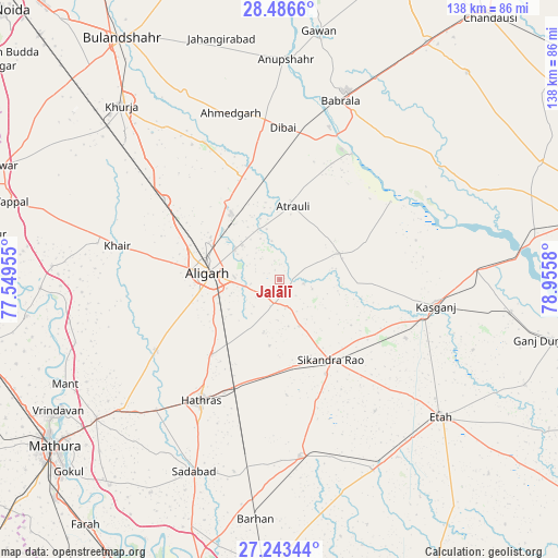
Jalālī GPS coordinates[2]
27° 52' 0.48" North, 78° 15' 9.612" East
| Map corner | latitude | longitude |
|---|---|---|
| Upper-left | 28.4866°, | 77.54955° |
| Center: | 27.8668°, | 78.25267° |
| Lower-right: | 27.24344°, | 78.9558° |
| Map W x H: | 138.2×138.2 km | = 85.9×85.9mi |
| max Lat: | 34.9274° ⇑16.2% North |
| Jalālī: | 27.8668° |
| min Lat: | ⇓83.8% South 8.09008° |
| min Long | Jalālī | max Long |
| 68.82655° | 78.25267° | 96.81° |
| W 51.7%⇐ | ⇒48.3% E |
Elevation
Elevation of Jalālī is 190 m = 623 ft, and this is 105.6 m = 346 ft below average elevation for this country.
| Max E: |
3681 m = 12077 ft | 52% |
| Avg. | 295.6 m = 970 ft | |
| Jalālī | 190 m = 623 ft | |
Min E: |
1 m = 3 ft | 48% |
See also: India elevation on elevation.city.
Geographical zone
Jalālī is located in North temperate zone (between Tropic of Cancer and the Arctic Circle). Distance of this Northern Tropic circle is 492.6 km =306.1 mi to South.| Distance of | km | miles | from Jalālī |
|---|---|---|---|
| North Pole | 6908.6 | 4292.8 | to North |
| Arctic Circle | 4302.7 | 2673.6 | to North |
| Tropic Cancer | 492.6 | 306.1 | to South |
| Equator | 3098.5 | 1925.3 | to South |


Nearby cities:
15 places around Jalālī: (largest is in red/bold)
• Alīgarh
17.6 km =10.9 mi,  275°
275°
• Atraulī
18.4 km =11.4 mi,  10°
10°
• Chharra
15.9 km =9.9 mi,  66°
66°
• Dibai
38 km =23.6 mi,  1°
1°
• Harduāganj
12.6 km =7.8 mi,  312°
312°
• Hāthras
36.1 km =22.4 mi,  213°
213°
• Iglās
35.3 km =21.9 mi,  240°
240°
• Jalesar
44.1 km =27.4 mi,  173°
173°
• Khair
41.2 km =25.6 mi, 281°
• Kāsganj
39.2 km =24.4 mi,  99°
99°
• Mārahra
34.3 km =21.3 mi,  114°
114°
• Naraura
39.5 km =24.5 mi,  19°
19°
• Pahāsu
38.7 km =24 mi,  331°
331°
• Sikandra Rao
23.4 km =14.5 mi,  147°
147°
• Sāsni
24.7 km =15.3 mi,  222°
222°
Sources, notices
• [Note1] Compared only with cities in India existing in our database
• [Src1] Map data: © OpenStreetMap contributors (CC-BY-SA)
• [Src2] Other city data from geonames.org with taken over terms of usage.
• [Src3] Geographical zone / Annual Mean Temperature by Robert A. Rohde @ Wikipedia
