Atraulī geodata
Atraulī (Uttar Pradesh) is a populated place; located in India in Asia/Kolkata (GMT+5.5) time zone. With population of 47,512 people, there are 928 cities with bigger population in this country. Compared to other cities in India, 84.6% of cities are located further ↓South; 52.2% of cities are located further ←West and 51.4% of cities have higher elevation than Atraulī. Note1


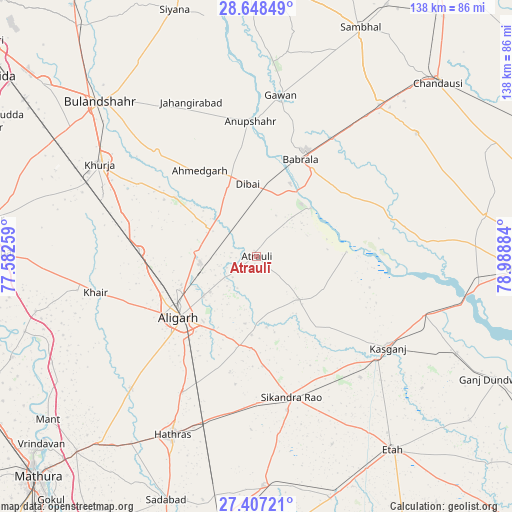
Atraulī GPS coordinates[2]
28° 1' 46.704" North, 78° 17' 8.556" East
| Map corner | latitude | longitude |
|---|---|---|
| Upper-left | 28.64849°, | 77.58259° |
| Center: | 28.02964°, | 78.28571° |
| Lower-right: | 27.40721°, | 78.98884° |
| Map W x H: | 138×138 km | = 85.7×85.7mi |
| max Lat: | 34.9274° ⇑15.4% North |
| Atraulī: | 28.02964° |
| min Lat: | ⇓84.6% South 8.09008° |
| min Long | Atraulī | max Long |
| 68.82655° | 78.28571° | 96.81° |
| W 52.2%⇐ | ⇒47.8% E |
Elevation
Elevation of Atraulī is 194 m = 636 ft, and this is 101.6 m = 333 ft below average elevation for this country.
| Max E: |
3681 m = 12077 ft | 51.4% |
| Avg. | 295.6 m = 970 ft | |
| Atraulī | 194 m = 636 ft | |
Min E: |
1 m = 3 ft | 48.6% |
See also: Atraulī elevation on elevation.city.
Geographical zone
Atraulī is located in North temperate zone (between Tropic of Cancer and the Arctic Circle). Distance of this Northern Tropic circle is 510.7 km =317.3 mi to South.| Distance of | km | miles | from Atraulī |
|---|---|---|---|
| North Pole | 6890.5 | 4281.6 | to North |
| Arctic Circle | 4284.6 | 2662.3 | to North |
| Tropic Cancer | 510.7 | 317.3 | to South |
| Equator | 3116.6 | 1936.6 | to South |


Nearby cities:
15 places around Atraulī: (largest is in red/bold)
• Alīgarh
26.5 km =16.5 mi,  231°
231°
• Anūpshahr
36.5 km =22.7 mi,  357°
357°
• Babrāla
28.6 km =17.8 mi,  24°
24°
• Chharra
16.3 km =10.1 mi,  135°
135°
• Dibai
20 km =12.4 mi,  353°
353°
• Gunnaur
27.8 km =17.3 mi,  32°
32°
• Harduāganj
15.8 km =9.8 mi, 232°
• Jalālī
18.4 km =11.4 mi,  190°
190°
• Kāsganj
43.1 km =26.8 mi,  124°
124°
• Mārahra
42.8 km =26.6 mi, 139°
• Naraura
21.5 km =13.4 mi, 27°
• Pahāsu
26.9 km =16.7 mi,  306°
306°
• Shikārpūr
38.6 km =24 mi,  316°
316°
• Sikandra Rao
39 km =24.2 mi,  166°
166°
• Sāsni
41.4 km =25.7 mi,  208°
208°
Sources, notices
• [Note1] Compared only with cities in India existing in our database
• [Src1] Map data: © OpenStreetMap contributors (CC-BY-SA)
• [Src2] Other city data from geonames.org with taken over terms of usage.
• [Src3] Geographical zone / Annual Mean Temperature by Robert A. Rohde @ Wikipedia
