Sikandra Rao geodata
Sikandra Rao (Uttar Pradesh) is a populated place; located in India in Asia/Kolkata (GMT+5.5) time zone. With population of 42,229 people, there are 1046 cities with bigger population in this country. Compared to other cities in India, 82.9% of cities are located further ↓South; 52.9% of cities are located further ←West and 52.7% of cities have higher elevation than Sikandra Rao. Note1


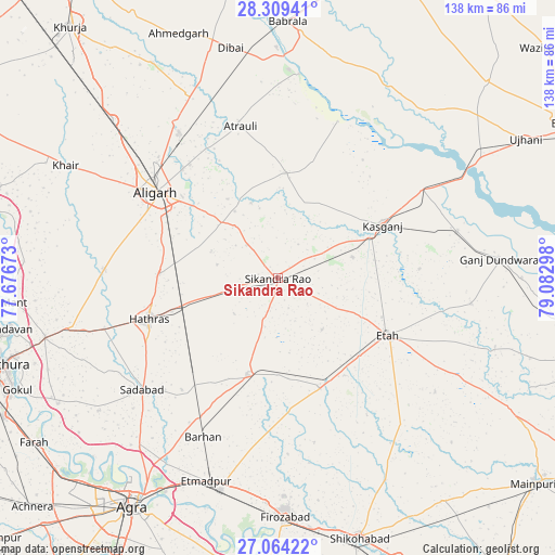
Sikandra Rao GPS coordinates[2]
27° 41' 18.924" North, 78° 22' 47.46" East
| Map corner | latitude | longitude |
|---|---|---|
| Upper-left | 28.30941°, | 77.67673° |
| Center: | 27.68859°, | 78.37985° |
| Lower-right: | 27.06422°, | 79.08298° |
| Map W x H: | 138.5×138.5 km | = 86.1×86.1mi |
| max Lat: | 34.9274° ⇑17.1% North |
| Sikandra Rao: | 27.68859° |
| min Lat: | ⇓82.9% South 8.09008° |
| min Long | Sikandra Rao | max Long |
| 68.82655° | 78.37985° | 96.81° |
| W 52.9%⇐ | ⇒47.1% E |
Elevation
Elevation of Sikandra Rao is 186 m = 610 ft, and this is 109.6 m = 360 ft below average elevation for this country.
| Max E: |
3681 m = 12077 ft | 52.7% |
| Avg. | 295.6 m = 970 ft | |
| Sikandra Rao | 186 m = 610 ft | |
Min E: |
1 m = 3 ft | 47.3% |
See also: Sikandra Rao elevation on elevation.city.
Geographical zone
Sikandra Rao is located in North temperate zone (between Tropic of Cancer and the Arctic Circle). Distance of this Northern Tropic circle is 472.8 km =293.8 mi to South.| Distance of | km | miles | from Sikandra Rao |
|---|---|---|---|
| North Pole | 6928.4 | 4305.1 | to North |
| Arctic Circle | 4322.5 | 2685.9 | to North |
| Tropic Cancer | 472.8 | 293.8 | to South |
| Equator | 3078.7 | 1913 | to South |


Nearby cities:
15 places around Sikandra Rao: (largest is in red/bold)
• Alīgarh
36.9 km =22.9 mi,  305°
305°
• Amānpur
35.3 km =21.9 mi,  85°
85°
• Atraulī
39 km =24.2 mi,  346°
346°
• Chharra
26.3 km =16.3 mi,  4°
4°
• Harduāganj
35.8 km =22.2 mi,  322°
322°
• Hāthras
33.9 km =21.1 mi,  252°
252°
• Iglās
43.4 km =27 mi,  273°
273°
• Jalesar
25.1 km =15.6 mi,  197°
197°
• Jalālī
23.4 km =14.5 mi,  327°
327°
• Kāsganj
29.4 km =18.3 mi,  62°
62°
• Mārahra
19.4 km =12.1 mi,  73°
73°
• Pharihā
41.8 km =26 mi,  167°
167°
• Sadābād
43.7 km =27.2 mi,  230°
230°
• Soron
42.5 km =26.4 mi, 58°
• Sāsni
29.3 km =18.2 mi, 273°
Sources, notices
• [Note1] Compared only with cities in India existing in our database
• [Src1] Map data: © OpenStreetMap contributors (CC-BY-SA)
• [Src2] Other city data from geonames.org with taken over terms of usage.
• [Src3] Geographical zone / Annual Mean Temperature by Robert A. Rohde @ Wikipedia
