Mālpur geodata
Mālpur (Gujarat) is a populated place; located in India in Asia/Kolkata (GMT+5.5) time zone. With population of 6,971 people, there are 3213 cities with bigger population in this country. Compared to other cities in India, 54% of cities are located further ↓South; 92.7% of cities are located further →East and 60.6% of cities have higher elevation than Mālpur. Note1


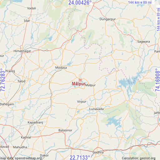
Mālpur GPS coordinates[2]
23° 21' 37.26" North, 73° 27' 57.42" East
| Map corner | latitude | longitude |
|---|---|---|
| Upper-left | 24.00426°, | 72.76283° |
| Center: | 23.36035°, | 73.46595° |
| Lower-right: | 22.7133°, | 74.16908° |
| Map W x H: | 143.5×143.5 km | = 89.2×89.2mi |
| max Lat: | 34.9274° ⇑46% North |
| Mālpur: | 23.36035° |
| min Lat: | ⇓54% South 8.09008° |
| min Long | Mālpur | max Long |
| 68.82655° | 73.46595° | 96.81° |
| W 7.3%⇐ | ⇒92.7% E |
Elevation
Elevation of Mālpur is 145 m = 476 ft, and this is 150.6 m = 494 ft below average elevation for this country.
| Max E: |
3681 m = 12077 ft | 60.6% |
| Avg. | 295.6 m = 970 ft | |
| Mālpur | 145 m = 476 ft | |
Min E: |
1 m = 3 ft | 39.4% |
See also: India elevation on elevation.city.
Geographical zone
Mālpur is located in North Torrid zone (between Equator and Tropic of Cancer). Distance of this Northern Tropic circle is 8.5 km =5.3 mi to North.| Distance of | km | miles | from Mālpur |
|---|---|---|---|
| North Pole | 7409.6 | 4604.1 | to North |
| Arctic Circle | 4803.7 | 2984.9 | to North |
| Tropic Cancer | 8.5 | 5.3 | to North |
| Equator | 2597.4 | 1613.9 | to South |


Nearby cities:
15 places around Mālpur: (largest is in red/bold)
• Chhala
70.9 km =44.1 mi,  265°
265°
• Dahegām
69.2 km =43 mi,  252°
252°
• Dākor
74.9 km =46.5 mi,  205°
205°
• Dūngarpur
59.4 km =36.9 mi,  25°
25°
• Galiākot
59.3 km =36.8 mi,  72°
72°
• Godhra
66.8 km =41.5 mi,  166°
166°
• Himatnagar
57.5 km =35.7 mi,  297°
297°
• Kapadvanj
55.1 km =34.2 mi,  227°
227°
• Lūnāvāda
29.7 km =18.5 mi,  150°
150°
• Meghraj
16.1 km =10 mi,  17°
17°
• Modāsa
20.5 km =12.7 mi, 303°
• Morwa
63.4 km =39.4 mi,  143°
143°
• Thāsra
67.7 km =42.1 mi,  202°
202°
• Vejalpur
75.2 km =46.7 mi, 172°
• Virpur
19.1 km =11.9 mi,  175°
175°
Sources, notices
• [Note1] Compared only with cities in India existing in our database
• [Src1] Map data: © OpenStreetMap contributors (CC-BY-SA)
• [Src2] Other city data from geonames.org with taken over terms of usage.
• [Src3] Geographical zone / Annual Mean Temperature by Robert A. Rohde @ Wikipedia
