Galiākot geodata
Galiākot (Rajasthan) is a populated place; located in India in Asia/Kolkata (GMT+5.5) time zone. With population of 6,906 people, there are 3218 cities with bigger population in this country. Compared to other cities in India, 54.9% of cities are located further ↓South; 89.2% of cities are located further →East and 62.3% of cities have higher elevation than Galiākot. Note1


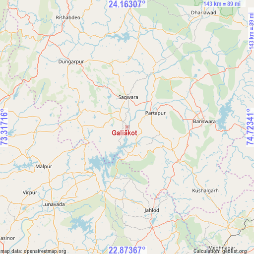
Galiākot GPS coordinates[2]
23° 31' 11.82" North, 74° 1' 13.008" East
| Map corner | latitude | longitude |
|---|---|---|
| Upper-left | 24.16307°, | 73.31716° |
| Center: | 23.51995°, | 74.02028° |
| Lower-right: | 22.87367°, | 74.72341° |
| Map W x H: | 143.4×143.4 km | = 89.1×89.1mi |
| max Lat: | 34.9274° ⇑45.1% North |
| Galiākot: | 23.51995° |
| min Lat: | ⇓54.9% South 8.09008° |
| min Long | Galiākot | max Long |
| 68.82655° | 74.02028° | 96.81° |
| W 10.8%⇐ | ⇒89.2% E |
Elevation
Elevation of Galiākot is 136 m = 446 ft, and this is 159.6 m = 524 ft below average elevation for this country.
| Max E: |
3681 m = 12077 ft | 62.3% |
| Avg. | 295.6 m = 970 ft | |
| Galiākot | 136 m = 446 ft | |
Min E: |
1 m = 3 ft | 37.7% |
See also: India elevation on elevation.city.
Geographical zone
Galiākot is located in North temperate zone (between Tropic of Cancer and the Arctic Circle). Distance of this Northern Tropic circle is 9.3 km =5.8 mi to South.| Distance of | km | miles | from Galiākot |
|---|---|---|---|
| North Pole | 7391.9 | 4593.1 | to North |
| Arctic Circle | 4786 | 2973.9 | to North |
| Tropic Cancer | 9.3 | 5.8 | to South |
| Equator | 2615.2 | 1625 | to South |


Nearby cities:
15 places around Galiākot: (largest is in red/bold)
• Bamna
89.3 km =55.5 mi,  121°
121°
• Bānswāra
43.1 km =26.8 mi,  86°
86°
• Devgadh Bāriya
91.3 km =56.7 mi,  187°
187°
• Dohad
80.2 km =49.8 mi,  162°
162°
• Dūngarpur
47.5 km =29.5 mi,  319°
319°
• Kushālgarh
56.6 km =35.2 mi,  129°
129°
• Lūnāvāda
60.4 km =37.5 mi,  223°
223°
• Meghraj
51.7 km =32.1 mi,  267°
267°
• Modāsa
73.9 km =45.9 mi, 265°
• Morwa
70.9 km =44.1 mi,  195°
195°
• Mālpur
59.3 km =36.8 mi,  252°
252°
• Partāpur
17.6 km =10.9 mi,  62°
62°
• Sālūmbar
68.5 km =42.6 mi,  2°
2°
• Thandla
80.4 km =50 mi, 134°
• Virpur
66.3 km =41.2 mi,  236°
236°
Sources, notices
• [Note1] Compared only with cities in India existing in our database
• [Src1] Map data: © OpenStreetMap contributors (CC-BY-SA)
• [Src2] Other city data from geonames.org with taken over terms of usage.
• [Src3] Geographical zone / Annual Mean Temperature by Robert A. Rohde @ Wikipedia
