Meghraj geodata
Meghraj (Gujarat) is a populated place; located in India in Asia/Kolkata (GMT+5.5) time zone. With population of 10,498 people, there are 2891 cities with bigger population in this country. Compared to other cities in India, 54.8% of cities are located further ↓South; 92.5% of cities are located further →East and 56.4% of cities have higher elevation than Meghraj. Note1


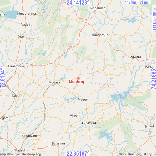
Meghraj GPS coordinates[2]
23° 29' 52.98" North, 73° 30' 48.672" East
| Map corner | latitude | longitude |
|---|---|---|
| Upper-left | 24.14128°, | 72.8104° |
| Center: | 23.49805°, | 73.51352° |
| Lower-right: | 22.85167°, | 74.21665° |
| Map W x H: | 143.4×143.4 km | = 89.1×89.1mi |
| max Lat: | 34.9274° ⇑45.2% North |
| Meghraj: | 23.49805° |
| min Lat: | ⇓54.8% South 8.09008° |
| min Long | Meghraj | max Long |
| 68.82655° | 73.51352° | 96.81° |
| W 7.5%⇐ | ⇒92.5% E |
Elevation
Elevation of Meghraj is 168 m = 551 ft, and this is 127.6 m = 419 ft below average elevation for this country.
| Max E: |
3681 m = 12077 ft | 56.4% |
| Avg. | 295.6 m = 970 ft | |
| Meghraj | 168 m = 551 ft | |
Min E: |
1 m = 3 ft | 43.6% |
See also: India elevation on elevation.city.
Geographical zone
Meghraj is located in North temperate zone (between Tropic of Cancer and the Arctic Circle). Distance of this Northern Tropic circle is 6.8 km =4.2 mi to South.| Distance of | km | miles | from Meghraj |
|---|---|---|---|
| North Pole | 7394.3 | 4594.6 | to North |
| Arctic Circle | 4788.4 | 2975.4 | to North |
| Tropic Cancer | 6.8 | 4.2 | to South |
| Equator | 2612.7 | 1623.5 | to South |


Nearby cities:
15 places around Meghraj: (largest is in red/bold)
• Chhala
78.4 km =48.7 mi,  254°
254°
• Dahegām
79.6 km =49.5 mi,  242°
242°
• Dūngarpur
43.5 km =27 mi,  28°
28°
• Galiākot
51.7 km =32.1 mi,  87°
87°
• Godhra
81 km =50.3 mi,  172°
172°
• Himatnagar
56.9 km =35.4 mi,  281°
281°
• Kapadvanj
69.5 km =43.2 mi,  220°
220°
• Khedbrahma
75.9 km =47.2 mi,  321°
321°
• Lūnāvāda
42.3 km =26.3 mi, 166°
• Modāsa
22.3 km =13.9 mi,  259°
259°
• Morwa
73.9 km =45.9 mi,  153°
153°
• Mālpur
16.1 km =10 mi,  197°
197°
• Partāpur
68.1 km =42.3 mi,  81°
81°
• Vijāpur
78.3 km =48.7 mi, 275°
• Virpur
34.5 km =21.4 mi,  185°
185°
Sources, notices
• [Note1] Compared only with cities in India existing in our database
• [Src1] Map data: © OpenStreetMap contributors (CC-BY-SA)
• [Src2] Other city data from geonames.org with taken over terms of usage.
• [Src3] Geographical zone / Annual Mean Temperature by Robert A. Rohde @ Wikipedia
