Dūngarpur geodata
Dūngarpur (Rajasthan) is a populated place; located in India in Asia/Kolkata (GMT+5.5) time zone. With population of 45,195 people, there are 982 cities with bigger population in this country. Compared to other cities in India, 57.3% of cities are located further ↓South; 91.7% of cities are located further →East and 65.9% of cities have lower elevation than Dūngarpur. Note1


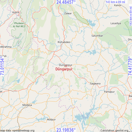
Dūngarpur GPS coordinates[2]
23° 50' 35.016" North, 73° 42' 52.776" East
| Map corner | latitude | longitude |
|---|---|---|
| Upper-left | 24.48457°, | 73.01154° |
| Center: | 23.84306°, | 73.71466° |
| Lower-right: | 23.19836°, | 74.41779° |
| Map W x H: | 143×143 km | = 88.9×88.9mi |
| max Lat: | 34.9274° ⇑42.7% North |
| Dūngarpur: | 23.84306° |
| min Lat: | ⇓57.3% South 8.09008° |
| min Long | Dūngarpur | max Long |
| 68.82655° | 73.71466° | 96.81° |
| W 8.3%⇐ | ⇒91.7% E |
Elevation
Elevation of Dūngarpur is 292 m = 958 ft, and this is 3.6 m = 12 ft below average elevation for this country.
| Max E: |
3681 m = 12077 ft | 34.1% |
| Avg. | 295.6 m = 970 ft | |
| Dūngarpur | 292 m = 958 ft | |
Min E: |
1 m = 3 ft | 65.9% |
See also: Dūngarpur elevation on elevation.city.
Geographical zone
Dūngarpur is located in North temperate zone (between Tropic of Cancer and the Arctic Circle). Distance of this Northern Tropic circle is 45.2 km =28.1 mi to South.| Distance of | km | miles | from Dūngarpur |
|---|---|---|---|
| North Pole | 7356 | 4570.8 | to North |
| Arctic Circle | 4750.1 | 2951.6 | to North |
| Tropic Cancer | 45.2 | 28.1 | to South |
| Equator | 2651.1 | 1647.3 | to South |


Nearby cities:
15 places around Dūngarpur: (largest is in red/bold)
• Bari Sādri
99.7 km =62 mi,  50°
50°
• Bhindār
87.5 km =54.4 mi,  33°
33°
• Bānswāra
81.4 km =50.6 mi,  114°
114°
• Galiākot
47.5 km =29.5 mi,  139°
139°
• Himatnagar
80.9 km =50.3 mi,  250°
250°
• Khedbrahma
71 km =44.1 mi,  287°
287°
• Kānor
86.3 km =53.6 mi,  40°
40°
• Lūnāvāda
80.2 km =49.8 mi,  187°
187°
• Meghraj
43.5 km =27 mi,  208°
208°
• Modāsa
59.9 km =37.2 mi,  225°
225°
• Mālpur
59.4 km =36.9 mi, 205°
• Partāpur
54.4 km =33.8 mi,  120°
120°
• Sālūmbar
46.7 km =29 mi, 45°
• Udaipur
82.6 km =51.3 mi,  359°
359°
• Virpur
76.5 km =47.5 mi,  198°
198°
Sources, notices
• [Note1] Compared only with cities in India existing in our database
• [Src1] Map data: © OpenStreetMap contributors (CC-BY-SA)
• [Src2] Other city data from geonames.org with taken over terms of usage.
• [Src3] Geographical zone / Annual Mean Temperature by Robert A. Rohde @ Wikipedia
