Maksi geodata
Maksi (Madhya Pradesh) is a populated place; located in India in Asia/Kolkata (GMT+5.5) time zone. With population of 20,094 people, there are 2035 cities with bigger population in this country. Compared to other cities in India, 53.4% of cities are located further ↓South; 72.2% of cities are located further →East and 82.7% of cities have lower elevation than Maksi. Note1


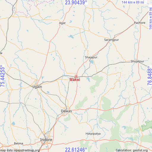
Maksi GPS coordinates[2]
23° 15' 35.964" North, 76° 8' 44.412" East
| Map corner | latitude | longitude |
|---|---|---|
| Upper-left | 23.90439°, | 75.44255° |
| Center: | 23.25999°, | 76.14567° |
| Lower-right: | 22.61246°, | 76.8488° |
| Map W x H: | 143.6×143.7 km | = 89.2×89.3mi |
| max Lat: | 34.9274° ⇑46.6% North |
| Maksi: | 23.25999° |
| min Lat: | ⇓53.4% South 8.09008° |
| min Long | Maksi | max Long |
| 68.82655° | 76.14567° | 96.81° |
| W 27.8%⇐ | ⇒72.2% E |
Elevation
Elevation of Maksi is 503 m = 1650 ft, and this is 207.4 m = 680 ft above average elevation for this country.
| Max E: |
3681 m = 12077 ft | 17.3% |
| Maksi | 503 m 1650 ft | |
| Avg. | 295.6 m = 970 ft | |
Min E: |
1 m = 3 ft | 82.7% |
See also: India elevation on elevation.city.
Geographical zone
Maksi is located in North Torrid zone (between Equator and Tropic of Cancer). Distance of this Northern Tropic circle is 19.7 km =12.2 mi to North.| Distance of | km | miles | from Maksi |
|---|---|---|---|
| North Pole | 7420.8 | 4611.1 | to North |
| Arctic Circle | 4814.9 | 2991.8 | to North |
| Tropic Cancer | 19.7 | 12.2 | to North |
| Equator | 2586.3 | 1607.1 | to South |


Nearby cities:
15 places around Maksi: (largest is in red/bold)
• Agar
52 km =32.3 mi,  345°
345°
• Akodia
48.2 km =30 mi,  73°
73°
• Ashta
64.8 km =40.3 mi,  114°
114°
• Dewas
34 km =21.1 mi,  195°
195°
• Hātod
66.5 km =41.3 mi,  218°
218°
• Iklehra
28 km =17.4 mi,  116°
116°
• Indore
68.2 km =42.4 mi,  207°
207°
• Iāwar
45.8 km =28.5 mi,  127°
127°
• Shujālpur
59.9 km =37.2 mi, 74°
• Shājāpur
22.9 km =14.2 mi,  36°
36°
• Sānwer
45.5 km =28.3 mi,  225°
225°
• Sārangpur
47.7 km =29.6 mi, 44°
• Tarāna
13.4 km =8.3 mi,  307°
307°
• Ujjain
38.7 km =24 mi,  257°
257°
• Unhel
60.5 km =37.6 mi,  278°
278°
Sources, notices
• [Note1] Compared only with cities in India existing in our database
• [Src1] Map data: © OpenStreetMap contributors (CC-BY-SA)
• [Src2] Other city data from geonames.org with taken over terms of usage.
• [Src3] Geographical zone / Annual Mean Temperature by Robert A. Rohde @ Wikipedia
