Tarāna geodata
Tarāna (Madhya Pradesh) is a populated place; located in India in Asia/Kolkata (GMT+5.5) time zone. With population of 22,773 people, there are 1851 cities with bigger population in this country. Compared to other cities in India, 53.9% of cities are located further ↓South; 73.2% of cities are located further →East and 82.5% of cities have lower elevation than Tarāna. Note1


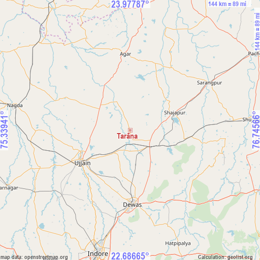
Tarāna GPS coordinates[2]
23° 20' 1.788" North, 76° 2' 33.108" East
| Map corner | latitude | longitude |
|---|---|---|
| Upper-left | 23.97787°, | 75.33941° |
| Center: | 23.33383°, | 76.04253° |
| Lower-right: | 22.68665°, | 76.74566° |
| Map W x H: | 143.6×143.6 km | = 89.2×89.2mi |
| max Lat: | 34.9274° ⇑46.1% North |
| Tarāna: | 23.33383° |
| min Lat: | ⇓53.9% South 8.09008° |
| min Long | Tarāna | max Long |
| 68.82655° | 76.04253° | 96.81° |
| W 26.8%⇐ | ⇒73.2% E |
Elevation
Elevation of Tarāna is 501 m = 1644 ft, and this is 205.4 m = 674 ft above average elevation for this country.
| Max E: |
3681 m = 12077 ft | 17.5% |
| Tarāna | 501 m 1644 ft | |
| Avg. | 295.6 m = 970 ft | |
Min E: |
1 m = 3 ft | 82.5% |
See also: India elevation on elevation.city.
Geographical zone
Tarāna is located in North Torrid zone (between Equator and Tropic of Cancer). Distance of this Northern Tropic circle is 11.4 km =7.1 mi to North.| Distance of | km | miles | from Tarāna |
|---|---|---|---|
| North Pole | 7412.6 | 4606 | to North |
| Arctic Circle | 4806.7 | 2986.7 | to North |
| Tropic Cancer | 11.4 | 7.1 | to North |
| Equator | 2594.5 | 1612.1 | to South |


Nearby cities:
15 places around Tarāna: (largest is in red/bold)
• Agar
42.1 km =26.2 mi,  356°
356°
• Akodia
57 km =35.4 mi,  84°
84°
• Dewas
40.9 km =25.4 mi,  178°
178°
• Gautampura
66 km =41 mi,  234°
234°
• Gogāpur
59.1 km =36.7 mi,  294°
294°
• Iklehra
41.2 km =25.6 mi,  120°
120°
• Iāwar
59.1 km =36.7 mi,  127°
127°
• Maksi
13.4 km =8.3 mi, 127°
• Nagda
65.3 km =40.6 mi,  282°
282°
• Piploda
62.2 km =38.6 mi,  271°
271°
• Shājāpur
26.1 km =16.2 mi,  66°
66°
• Sānwer
45.7 km =28.4 mi,  208°
208°
• Sārangpur
51 km =31.7 mi,  59°
59°
• Ujjain
32 km =19.9 mi,  238°
238°
• Unhel
49.3 km =30.6 mi, 270°
Sources, notices
• [Note1] Compared only with cities in India existing in our database
• [Src1] Map data: © OpenStreetMap contributors (CC-BY-SA)
• [Src2] Other city data from geonames.org with taken over terms of usage.
• [Src3] Geographical zone / Annual Mean Temperature by Robert A. Rohde @ Wikipedia
