Sārangpur geodata
Sārangpur (Madhya Pradesh) is a populated place; located in India in Asia/Kolkata (GMT+5.5) time zone. With population of 35,827 people, there are 1210 cities with bigger population in this country. Compared to other cities in India, 55.2% of cities are located further ↓South; 68.8% of cities are located further →East and 78% of cities have lower elevation than Sārangpur. Note1


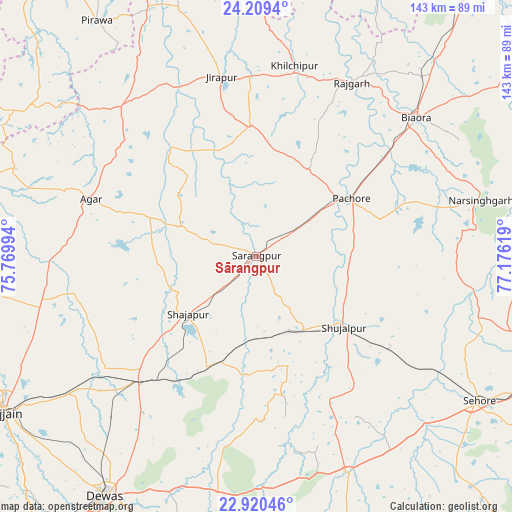
Sārangpur GPS coordinates[2]
23° 33' 59.436" North, 76° 28' 23.016" East
| Map corner | latitude | longitude |
|---|---|---|
| Upper-left | 24.2094°, | 75.76994° |
| Center: | 23.56651°, | 76.47306° |
| Lower-right: | 22.92046°, | 77.17619° |
| Map W x H: | 143.3×143.3 km | = 89×89mi |
| max Lat: | 34.9274° ⇑44.8% North |
| Sārangpur: | 23.56651° |
| min Lat: | ⇓55.2% South 8.09008° |
| min Long | Sārangpur | max Long |
| 68.82655° | 76.47306° | 96.81° |
| W 31.2%⇐ | ⇒68.8% E |
Elevation
Elevation of Sārangpur is 431 m = 1414 ft, and this is 135.4 m = 444 ft above average elevation for this country.
| Max E: |
3681 m = 12077 ft | 22% |
| Sārangpur | 431 m 1414 ft | |
| Avg. | 295.6 m = 970 ft | |
Min E: |
1 m = 3 ft | 78% |
See also: India elevation on elevation.city.
Geographical zone
Sārangpur is located in North temperate zone (between Tropic of Cancer and the Arctic Circle). Distance of this Northern Tropic circle is 14.4 km =8.9 mi to South.| Distance of | km | miles | from Sārangpur |
|---|---|---|---|
| North Pole | 7386.7 | 4589.9 | to North |
| Arctic Circle | 4780.8 | 2970.7 | to North |
| Tropic Cancer | 14.4 | 8.9 | to South |
| Equator | 2620.4 | 1628.2 | to South |


Nearby cities:
15 places around Sārangpur: (largest is in red/bold)
• Agar
49.3 km =30.6 mi,  289°
289°
• Akodia
24.4 km =15.2 mi,  148°
148°
• Biaora
59.4 km =36.9 mi,  48°
48°
• Iklehra
47.4 km =29.5 mi,  190°
190°
• Iāwar
62 km =38.5 mi,  177°
177°
• Khilchipur
53.7 km =33.4 mi,  11°
11°
• Khujner
28.5 km =17.7 mi,  31°
31°
• Maksi
47.7 km =29.6 mi,  224°
224°
• Māchalpur
64.4 km =40 mi,  345°
345°
• Rājgarh
55.8 km =34.7 mi, 28°
• Shujālpur
30 km =18.6 mi,  126°
126°
• Shājāpur
25.3 km =15.7 mi,  231°
231°
• Susner
57.6 km =35.8 mi,  317°
317°
• Talen
26 km =16.2 mi,  89°
89°
• Tarāna
51 km =31.7 mi,  239°
239°
Sources, notices
• [Note1] Compared only with cities in India existing in our database
• [Src1] Map data: © OpenStreetMap contributors (CC-BY-SA)
• [Src2] Other city data from geonames.org with taken over terms of usage.
• [Src3] Geographical zone / Annual Mean Temperature by Robert A. Rohde @ Wikipedia
