Shājāpur geodata
Shājāpur (Madhya Pradesh) is a populated place; located in India in Asia/Kolkata (GMT+5.5) time zone. With population of 53,346 people, there are 832 cities with bigger population in this country. Compared to other cities in India, 54.4% of cities are located further ↓South; 70.9% of cities are located further →East and 79% of cities have lower elevation than Shājāpur. Note1


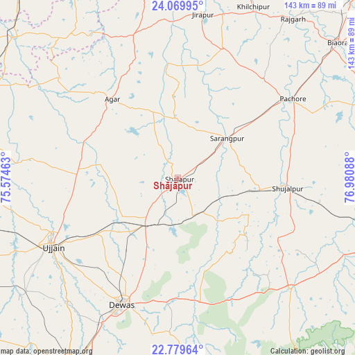
Shājāpur GPS coordinates[2]
23° 25' 34.932" North, 76° 16' 39.9" East
| Map corner | latitude | longitude |
|---|---|---|
| Upper-left | 24.06995°, | 75.57463° |
| Center: | 23.42637°, | 76.27775° |
| Lower-right: | 22.77964°, | 76.98088° |
| Map W x H: | 143.5×143.5 km | = 89.2×89.2mi |
| max Lat: | 34.9274° ⇑45.6% North |
| Shājāpur: | 23.42637° |
| min Lat: | ⇓54.4% South 8.09008° |
| min Long | Shājāpur | max Long |
| 68.82655° | 76.27775° | 96.81° |
| W 29.1%⇐ | ⇒70.9% E |
Elevation
Elevation of Shājāpur is 445 m = 1460 ft, and this is 149.4 m = 490 ft above average elevation for this country.
| Max E: |
3681 m = 12077 ft | 21% |
| Shājāpur | 445 m 1460 ft | |
| Avg. | 295.6 m = 970 ft | |
Min E: |
1 m = 3 ft | 79% |
See also: Shājāpur elevation on elevation.city.
Geographical zone
Shājāpur is located in North Torrid zone (between Equator and Tropic of Cancer). Distance of this Northern Tropic circle is 1.2 km =0.7 mi to North.| Distance of | km | miles | from Shājāpur |
|---|---|---|---|
| North Pole | 7402.3 | 4599.6 | to North |
| Arctic Circle | 4796.4 | 2980.3 | to North |
| Tropic Cancer | 1.2 | 0.7 | to North |
| Equator | 2604.8 | 1618.5 | to South |


Nearby cities:
15 places around Shājāpur: (largest is in red/bold)
• Agar
41.5 km =25.8 mi,  319°
319°
• Akodia
33.2 km =20.6 mi,  98°
98°
• Ashta
64.2 km =39.9 mi,  135°
135°
• Dewas
56 km =34.8 mi,  203°
203°
• Iklehra
33.2 km =20.6 mi,  159°
159°
• Iāwar
51.7 km =32.1 mi,  153°
153°
• Khujner
52.9 km =32.9 mi,  40°
40°
• Maksi
22.9 km =14.2 mi,  216°
216°
• Shujālpur
44.1 km =27.4 mi,  92°
92°
• Susner
61 km =37.9 mi,  341°
341°
• Sānwer
68.2 km =42.4 mi, 222°
• Sārangpur
25.3 km =15.7 mi,  51°
51°
• Talen
48.6 km =30.2 mi,  70°
70°
• Tarāna
26.1 km =16.2 mi,  246°
246°
• Ujjain
57.9 km =36 mi,  242°
242°
Sources, notices
• [Note1] Compared only with cities in India existing in our database
• [Src1] Map data: © OpenStreetMap contributors (CC-BY-SA)
• [Src2] Other city data from geonames.org with taken over terms of usage.
• [Src3] Geographical zone / Annual Mean Temperature by Robert A. Rohde @ Wikipedia
