Agar geodata
Agar (Madhya Pradesh) is a seat of a second-order administrative division; located in India in Asia/Kolkata (GMT+5.5) time zone. With population of 34,532 people, there are 1260 cities with bigger population in this country. Compared to other cities in India, 56.1% of cities are located further ↓South; 73.5% of cities are located further →East and 83.7% of cities have lower elevation than Agar. Note1


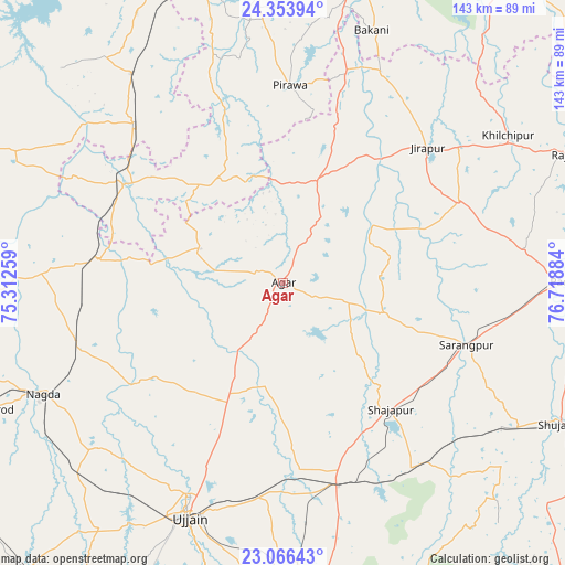
Agar GPS coordinates[2]
23° 42' 42.372" North, 76° 0' 56.556" East
| Map corner | latitude | longitude |
|---|---|---|
| Upper-left | 24.35394°, | 75.31259° |
| Center: | 23.71177°, | 76.01571° |
| Lower-right: | 23.06643°, | 76.71884° |
| Map W x H: | 143.2×143.2 km | = 89×89mi |
| max Lat: | 34.9274° ⇑43.9% North |
| Agar: | 23.71177° |
| min Lat: | ⇓56.1% South 8.09008° |
| min Long | Agar | max Long |
| 68.82655° | 76.01571° | 96.81° |
| W 26.5%⇐ | ⇒73.5% E |
Elevation
Elevation of Agar is 519 m = 1703 ft, and this is 223.4 m = 733 ft above average elevation for this country.
| Max E: |
3681 m = 12077 ft | 16.3% |
| Agar | 519 m 1703 ft | |
| Avg. | 295.6 m = 970 ft | |
Min E: |
1 m = 3 ft | 83.7% |
See also: India elevation on elevation.city.
Geographical zone
Agar is located in North temperate zone (between Tropic of Cancer and the Arctic Circle). Distance of this Northern Tropic circle is 30.6 km =19 mi to South.| Distance of | km | miles | from Agar |
|---|---|---|---|
| North Pole | 7370.6 | 4579.9 | to North |
| Arctic Circle | 4764.7 | 2960.6 | to North |
| Tropic Cancer | 30.6 | 19 | to South |
| Equator | 2636.5 | 1638.2 | to South |


Nearby cities:
15 places around Agar: (largest is in red/bold)
• Alot
47.1 km =29.3 mi,  276°
276°
• Gogāpur
53.7 km =33.4 mi,  251°
251°
• Khujner
61.8 km =38.4 mi,  82°
82°
• Maksi
52 km =32.3 mi,  165°
165°
• Māchalpur
55.4 km =34.4 mi,  33°
33°
• Nagda
67.1 km =41.7 mi, 245°
• Pirāwa
49.3 km =30.6 mi,  1°
1°
• Shājāpur
41.5 km =25.8 mi,  139°
139°
• Shāmgarh
65.4 km =40.6 mi,  324°
324°
• Susner
27.1 km =16.8 mi,  15°
15°
• Sārangpur
49.3 km =30.6 mi,  109°
109°
• Tarāna
42.1 km =26.2 mi,  176°
176°
• Tāl
64.2 km =39.9 mi,  270°
270°
• Ujjain
63.7 km =39.6 mi,  202°
202°
• Unhel
62.4 km =38.8 mi,  228°
228°
Sources, notices
• [Note1] Compared only with cities in India existing in our database
• [Src1] Map data: © OpenStreetMap contributors (CC-BY-SA)
• [Src2] Other city data from geonames.org with taken over terms of usage.
• [Src3] Geographical zone / Annual Mean Temperature by Robert A. Rohde @ Wikipedia
