Mahur geodata
Mahur (Assam) is a populated place; located in India in Asia/Kolkata (GMT+5.5) time zone. With population of 7,176 people, there are 3197 cities with bigger population in this country. Compared to other cities in India, 64.4% of cities are located further ↓South; 97.9% of cities are located further ←West and 88.4% of cities have lower elevation than Mahur. Note1


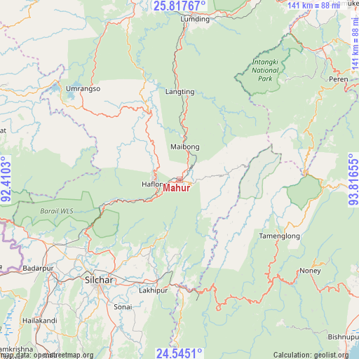
Mahur GPS coordinates[2]
25° 10' 58.98" North, 93° 6' 48.312" East
| Map corner | latitude | longitude |
|---|---|---|
| Upper-left | 25.81767°, | 92.4103° |
| Center: | 25.18305°, | 93.11342° |
| Lower-right: | 24.5451°, | 93.81655° |
| Map W x H: | 141.5×141.5 km | = 87.9×87.9mi |
| max Lat: | 34.9274° ⇑35.6% North |
| Mahur: | 25.18305° |
| min Lat: | ⇓64.4% South 8.09008° |
| min Long | Mahur | max Long |
| 68.82655° | 93.11342° | 96.81° |
| W 97.9%⇐ | ⇒2.1% E |
Elevation
Elevation of Mahur is 599 m = 1965 ft, and this is 303.4 m = 995 ft above average elevation for this country.
| Max E: |
3681 m = 12077 ft | 11.6% |
| Mahur | 599 m 1965 ft | |
| Avg. | 295.6 m = 970 ft | |
Min E: |
1 m = 3 ft | 88.4% |
See also: India elevation on elevation.city.
Geographical zone
Mahur is located in North temperate zone (between Tropic of Cancer and the Arctic Circle). Distance of this Northern Tropic circle is 194.2 km =120.7 mi to South.| Distance of | km | miles | from Mahur |
|---|---|---|---|
| North Pole | 7207 | 4478.2 | to North |
| Arctic Circle | 4601.1 | 2859 | to North |
| Tropic Cancer | 194.2 | 120.7 | to South |
| Equator | 2800.1 | 1739.9 | to South |


Nearby cities:
15 places around Mahur: (largest is in red/bold)
• Badarpur
62.8 km =39 mi,  236°
236°
• Bishnupur
89.9 km =55.9 mi,  133°
133°
• Diphu
80 km =49.7 mi,  23°
23°
• Hailākāndi
78.6 km =48.8 mi,  225°
225°
• Hāflong
9.9 km =6.2 mi,  258°
258°
• Imphal
93.5 km =58.1 mi,  116°
116°
• Jiribam
42.1 km =26.2 mi,  178°
178°
• Karīmganj
84 km =52.2 mi,  245°
245°
• Khliehriat
77.6 km =48.2 mi,  284°
284°
• Kāngpokpi
86.4 km =53.7 mi,  92°
92°
• Lakhipur
44.6 km =27.7 mi,  193°
193°
• Lumding Railway Colony
63.2 km =39.3 mi,  5°
5°
• Lāla
86.1 km =53.5 mi,  215°
215°
• Maibong
13.4 km =8.3 mi, 10°
• Silchar
50.7 km =31.5 mi, 218°
Sources, notices
• [Note1] Compared only with cities in India existing in our database
• [Src1] Map data: © OpenStreetMap contributors (CC-BY-SA)
• [Src2] Other city data from geonames.org with taken over terms of usage.
• [Src3] Geographical zone / Annual Mean Temperature by Robert A. Rohde @ Wikipedia
