Lakhipur geodata
Lakhipur (Assam) is a populated place; located in India in Asia/Kolkata (GMT+5.5) time zone. With population of 12,871 people, there are 2664 cities with bigger population in this country. Compared to other cities in India, 62.3% of cities are located further ↓South; 97.8% of cities are located further ←West and 83.5% of cities have higher elevation than Lakhipur. Note1


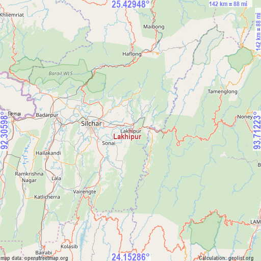
Lakhipur GPS coordinates[2]
24° 47' 34.116" North, 93° 0' 32.76" East
| Map corner | latitude | longitude |
|---|---|---|
| Upper-left | 25.42948°, | 92.30598° |
| Center: | 24.79281°, | 93.0091° |
| Lower-right: | 24.15286°, | 93.71223° |
| Map W x H: | 141.9×141.9 km | = 88.2×88.2mi |
| max Lat: | 34.9274° ⇑37.7% North |
| Lakhipur: | 24.79281° |
| min Lat: | ⇓62.3% South 8.09008° |
| min Long | Lakhipur | max Long |
| 68.82655° | 93.0091° | 96.81° |
| W 97.8%⇐ | ⇒2.2% E |
Elevation
Elevation of Lakhipur is 35 m = 115 ft, and this is 260.6 m = 855 ft below average elevation for this country.
| Max E: |
3681 m = 12077 ft | 83.5% |
| Avg. | 295.6 m = 970 ft | |
| Lakhipur | 35 m = 115 ft | |
Min E: |
1 m = 3 ft | 16.5% |
See also: India elevation on elevation.city.
Geographical zone
Lakhipur is located in North temperate zone (between Tropic of Cancer and the Arctic Circle). Distance of this Northern Tropic circle is 150.8 km =93.7 mi to South.| Distance of | km | miles | from Lakhipur |
|---|---|---|---|
| North Pole | 7250.4 | 4505.2 | to North |
| Arctic Circle | 4644.5 | 2886 | to North |
| Tropic Cancer | 150.8 | 93.7 | to South |
| Equator | 2756.7 | 1712.9 | to South |


Nearby cities:
15 places around Lakhipur: (largest is in red/bold)
• Badarpur
42.5 km =26.4 mi,  281°
281°
• Bishnupur
78.2 km =48.6 mi,  103°
103°
• Churāchāndpur
84.1 km =52.3 mi,  127°
127°
• Darlawn
87.1 km =54.1 mi,  185°
185°
• Hailākāndi
46.8 km =29.1 mi,  255°
255°
• Hāflong
41.4 km =25.7 mi,  1°
1°
• Jiribam
11.4 km =7.1 mi,  83°
83°
• Karīmganj
66.5 km =41.3 mi, 277°
• Kolasib
71.5 km =44.4 mi,  207°
207°
• Lāla
47.8 km =29.7 mi,  236°
236°
• Mahur
44.6 km =27.7 mi,  13°
13°
• Maibong
58 km =36 mi, 12°
• Moirāng
84.3 km =52.4 mi,  112°
112°
• Pherzawl
61.7 km =38.3 mi,  162°
162°
• Silchar
21.7 km =13.5 mi, 280°
Sources, notices
• [Note1] Compared only with cities in India existing in our database
• [Src1] Map data: © OpenStreetMap contributors (CC-BY-SA)
• [Src2] Other city data from geonames.org with taken over terms of usage.
• [Src3] Geographical zone / Annual Mean Temperature by Robert A. Rohde @ Wikipedia
