Deori geodata
Deori (Chhattisgarh) is a populated place; located in India in Asia/Kolkata (GMT+5.5) time zone. With population of 12,286 people, there are 2723 cities with bigger population in this country. Compared to other cities in India, 59.3% of cities are located further ↑North; 78.3% of cities are located further ←West and 62.4% of cities have lower elevation than Deori. Note1


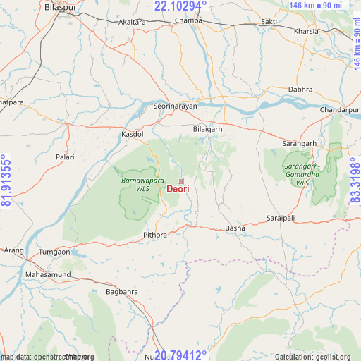
Deori GPS coordinates[2]
21° 27' 0" North, 82° 37' 0.012" East
| Map corner | latitude | longitude |
|---|---|---|
| Upper-left | 22.10294°, | 81.91355° |
| Center: | 21.45°, | 82.61667° |
| Lower-right: | 20.79412°, | 83.3198° |
| Map W x H: | 145.5×145.5 km | = 90.4×90.4mi |
| max Lat: | 34.9274° ⇑59.3% North |
| Deori: | 21.45° |
| min Lat: | ⇓40.7% South 8.09008° |
| min Long | Deori | max Long |
| 68.82655° | 82.61667° | 96.81° |
| W 78.3%⇐ | ⇒21.7% E |
Elevation
Elevation of Deori is 267 m = 876 ft, and this is 28.6 m = 94 ft below average elevation for this country.
| Max E: |
3681 m = 12077 ft | 37.6% |
| Avg. | 295.6 m = 970 ft | |
| Deori | 267 m = 876 ft | |
Min E: |
1 m = 3 ft | 62.4% |
See also: India elevation on elevation.city.
Geographical zone
Deori is located in North Torrid zone (between Equator and Tropic of Cancer). Distance of this Northern Tropic circle is 220.9 km =137.3 mi to North.| Distance of | km | miles | from Deori |
|---|---|---|---|
| North Pole | 7622 | 4736.1 | to North |
| Arctic Circle | 5016.2 | 3116.9 | to North |
| Tropic Cancer | 220.9 | 137.3 | to North |
| Equator | 2385 | 1482 | to South |


Nearby cities:
15 places around Deori: (largest is in red/bold)
• Akaltara
66.8 km =41.5 mi,  342°
342°
• Arang
72.8 km =45.2 mi,  247°
247°
• Baloda Bāzār
52.5 km =32.6 mi,  295°
295°
• Basna
28.9 km =18 mi,  131°
131°
• Chāmpa
65.1 km =40.5 mi,  2°
2°
• Jānjgīr
62.3 km =38.7 mi,  356°
356°
• Khamharia
64.9 km =40.3 mi,  215°
215°
• Kharod
32.9 km =20.4 mi,  353°
353°
• Mahāsamund
66.1 km =41.1 mi,  234°
234°
• Padampur
68.2 km =42.4 mi,  137°
137°
• Pithora
24.5 km =15.2 mi,  204°
204°
• Saktī
73.3 km =45.5 mi,  29°
29°
• Saraipali
43 km =26.7 mi,  110°
110°
• Seorīnārāyan
30.2 km =18.8 mi, 355°
• Sārangarh
50.1 km =31.1 mi,  72°
72°
Sources, notices
• [Note1] Compared only with cities in India existing in our database
• [Src1] Map data: © OpenStreetMap contributors (CC-BY-SA)
• [Src2] Other city data from geonames.org with taken over terms of usage.
• [Src3] Geographical zone / Annual Mean Temperature by Robert A. Rohde @ Wikipedia
