Salon geodata
Salon (Uttar Pradesh) is a populated place; located in India in Asia/Kolkata (GMT+5.5) time zone. With population of 14,312 people, there are 2529 cities with bigger population in this country. Compared to other cities in India, 70.6% of cities are located further ↓South; 74.5% of cities are located further ←West and 65.2% of cities have higher elevation than Salon. Note1


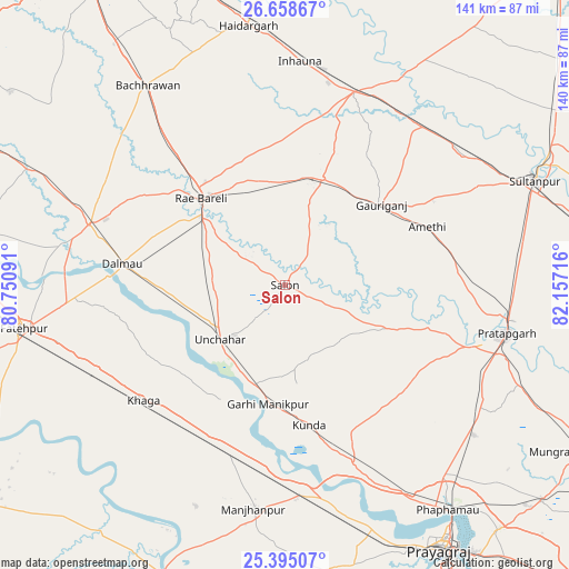
Salon GPS coordinates[2]
26° 1' 42.852" North, 81° 27' 14.508" East
| Map corner | latitude | longitude |
|---|---|---|
| Upper-left | 26.65867°, | 80.75091° |
| Center: | 26.02857°, | 81.45403° |
| Lower-right: | 25.39507°, | 82.15716° |
| Map W x H: | 140.5×140.5 km | = 87.3×87.3mi |
| max Lat: | 34.9274° ⇑29.4% North |
| Salon: | 26.02857° |
| min Lat: | ⇓70.6% South 8.09008° |
| min Long | Salon | max Long |
| 68.82655° | 81.45403° | 96.81° |
| W 74.5%⇐ | ⇒25.5% E |
Elevation
Elevation of Salon is 119 m = 390 ft, and this is 176.6 m = 579 ft below average elevation for this country.
| Max E: |
3681 m = 12077 ft | 65.2% |
| Avg. | 295.6 m = 970 ft | |
| Salon | 119 m = 390 ft | |
Min E: |
1 m = 3 ft | 34.8% |
See also: India elevation on elevation.city.
Geographical zone
Salon is located in North temperate zone (between Tropic of Cancer and the Arctic Circle). Distance of this Northern Tropic circle is 288.2 km =179.1 mi to South.| Distance of | km | miles | from Salon |
|---|---|---|---|
| North Pole | 7113 | 4419.8 | to North |
| Arctic Circle | 4507.1 | 2800.6 | to North |
| Tropic Cancer | 288.2 | 179.1 | to South |
| Equator | 2894.1 | 1798.3 | to South |


Nearby cities:
15 places around Salon: (largest is in red/bold)
• Amethī
37.9 km =23.5 mi,  67°
67°
• Antu
44.9 km =27.9 mi,  86°
86°
• Bela
55.5 km =34.5 mi,  102°
102°
• Bharwāri
52.1 km =32.4 mi,  175°
175°
• Dalmau
42.6 km =26.5 mi,  275°
275°
• Jais
27.9 km =17.3 mi,  19°
19°
• Khāga
45.2 km =28.1 mi,  230°
230°
• Kunda
35.2 km =21.9 mi,  170°
170°
• Lālganj
27.3 km =17 mi,  113°
113°
• Mahārājganj
43.1 km =26.8 mi,  335°
335°
• Musāfir-Khāna
51.7 km =32.1 mi,  41°
41°
• Parshādepur
6.3 km =3.9 mi, 37°
• Pratāpgarh
51 km =31.7 mi, 106°
• Raebareli
31.5 km =19.6 mi,  315°
315°
• Sirāthu
45 km =28 mi,  197°
197°
Sources, notices
• [Note1] Compared only with cities in India existing in our database
• [Src1] Map data: © OpenStreetMap contributors (CC-BY-SA)
• [Src2] Other city data from geonames.org with taken over terms of usage.
• [Src3] Geographical zone / Annual Mean Temperature by Robert A. Rohde @ Wikipedia
