Dalmau geodata
Dalmau (Uttar Pradesh) is a populated place; located in India in Asia/Kolkata (GMT+5.5) time zone. With population of 11,432 people, there are 2785 cities with bigger population in this country. Compared to other cities in India, 70.9% of cities are located further ↓South; 73% of cities are located further ←West and 66.7% of cities have higher elevation than Dalmau. Note1


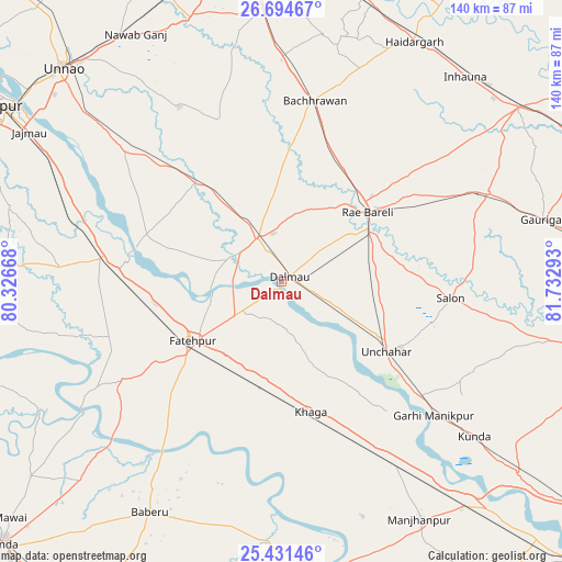
Dalmau GPS coordinates[2]
26° 3' 53.172" North, 81° 1' 47.28" East
| Map corner | latitude | longitude |
|---|---|---|
| Upper-left | 26.69467°, | 80.32668° |
| Center: | 26.06477°, | 81.0298° |
| Lower-right: | 25.43146°, | 81.73293° |
| Map W x H: | 140.5×140.5 km | = 87.3×87.3mi |
| max Lat: | 34.9274° ⇑29.1% North |
| Dalmau: | 26.06477° |
| min Lat: | ⇓70.9% South 8.09008° |
| min Long | Dalmau | max Long |
| 68.82655° | 81.0298° | 96.81° |
| W 73%⇐ | ⇒27% E |
Elevation
Elevation of Dalmau is 108 m = 354 ft, and this is 187.6 m = 615 ft below average elevation for this country.
| Max E: |
3681 m = 12077 ft | 66.7% |
| Avg. | 295.6 m = 970 ft | |
| Dalmau | 108 m = 354 ft | |
Min E: |
1 m = 3 ft | 33.3% |
See also: India elevation on elevation.city.
Geographical zone
Dalmau is located in North temperate zone (between Tropic of Cancer and the Arctic Circle). Distance of this Northern Tropic circle is 292.2 km =181.6 mi to South.| Distance of | km | miles | from Dalmau |
|---|---|---|---|
| North Pole | 7108.9 | 4417.3 | to North |
| Arctic Circle | 4503 | 2798 | to North |
| Tropic Cancer | 292.2 | 181.6 | to South |
| Equator | 2898.1 | 1800.8 | to South |


Nearby cities:
15 places around Dalmau: (largest is in red/bold)
• Bachhrāwān
46 km =28.6 mi,  10°
10°
• Bahua
47.8 km =29.7 mi,  238°
238°
• Bhagwantnagar
32.4 km =20.1 mi,  303°
303°
• Bindki
45.4 km =28.2 mi,  265°
265°
• Bīghāpur Khurd
48.7 km =30.3 mi,  310°
310°
• Fatehpur
26.5 km =16.5 mi,  234°
234°
• Khāga
33.4 km =20.8 mi,  167°
167°
• Kishanpur
47 km =29.2 mi,  180°
180°
• Mahārājganj
42.8 km =26.6 mi,  34°
34°
• Maurānwān
43.1 km =26.8 mi,  339°
339°
• Parshādepur
46.2 km =28.7 mi,  88°
88°
• Purwā
50.6 km =31.4 mi,  329°
329°
• Raebareli
27.4 km =17 mi,  47°
47°
• Salon
42.6 km =26.5 mi,  95°
95°
• Sirāthu
55.1 km =34.2 mi,  148°
148°
Sources, notices
• [Note1] Compared only with cities in India existing in our database
• [Src1] Map data: © OpenStreetMap contributors (CC-BY-SA)
• [Src2] Other city data from geonames.org with taken over terms of usage.
• [Src3] Geographical zone / Annual Mean Temperature by Robert A. Rohde @ Wikipedia
