Mahād geodata
Mahād (Maharashtra) is a populated place; located in India in Asia/Kolkata (GMT+5.5) time zone. With population of 26,665 people, there are 1601 cities with bigger population in this country. Compared to other cities in India, 71.6% of cities are located further ↑North; 92.9% of cities are located further →East and 95.4% of cities have higher elevation than Mahād. Note1


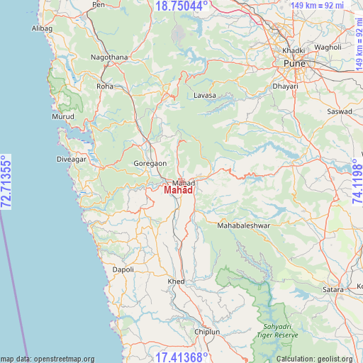
Mahād GPS coordinates[2]
18° 4' 59.988" North, 73° 25' 0.012" East
| Map corner | latitude | longitude |
|---|---|---|
| Upper-left | 18.75044°, | 72.71355° |
| Center: | 18.08333°, | 73.41667° |
| Lower-right: | 17.41368°, | 74.1198° |
| Map W x H: | 148.6×148.6 km | = 92.3×92.3mi |
| max Lat: | 34.9274° ⇑71.6% North |
| Mahād: | 18.08333° |
| min Lat: | ⇓28.4% South 8.09008° |
| min Long | Mahād | max Long |
| 68.82655° | 73.41667° | 96.81° |
| W 7.1%⇐ | ⇒92.9% E |
Elevation
Elevation of Mahād is 11 m = 36 ft, and this is 284.6 m = 934 ft below average elevation for this country.
| Max E: |
3681 m = 12077 ft | 95.4% |
| Avg. | 295.6 m = 970 ft | |
| Mahād | 11 m = 36 ft | |
Min E: |
1 m = 3 ft | 4.6% |
See also: India elevation on elevation.city.
Geographical zone
Mahād is located in North Torrid zone (between Equator and Tropic of Cancer). Distance of this Northern Tropic circle is 595.2 km =369.8 mi to North.| Distance of | km | miles | from Mahād |
|---|---|---|---|
| North Pole | 7996.4 | 4968.7 | to North |
| Arctic Circle | 5390.5 | 3349.5 | to North |
| Tropic Cancer | 595.2 | 369.8 | to North |
| Equator | 2010.7 | 1249.4 | to South |


Nearby cities:
15 places around Mahād: (largest is in red/bold)
• Bhor
45.7 km =28.4 mi,  80°
80°
• Goregaon
15.4 km =9.6 mi,  301°
301°
• Harnai
45.2 km =28.1 mi,  228°
228°
• Indāpur
29.8 km =18.5 mi,  323°
323°
• Jalgaon
45 km =28 mi,  212°
212°
• Kharakvasla
54.8 km =34.1 mi,  43°
43°
• Khed
40.6 km =25.2 mi,  182°
182°
• Khed
53.5 km =33.2 mi,  58°
58°
• Mahābaleshwar
58.2 km =36.2 mi, 181°
• Mhasla
32.7 km =20.3 mi,  279°
279°
• Murud
55.2 km =34.3 mi, 299°
• Pānchgani
44.3 km =27.5 mi,  113°
113°
• Roha
50.3 km =31.3 mi, 321°
• Srīvardhan
42.6 km =26.5 mi,  264°
264°
• Wai
52.2 km =32.4 mi, 106°
Sources, notices
• [Note1] Compared only with cities in India existing in our database
• [Src1] Map data: © OpenStreetMap contributors (CC-BY-SA)
• [Src2] Other city data from geonames.org with taken over terms of usage.
• [Src3] Geographical zone / Annual Mean Temperature by Robert A. Rohde @ Wikipedia
