Jalgaon geodata
Jalgaon (Maharashtra) is a populated place; located in India in Asia/Kolkata (GMT+5.5) time zone. With population of 5,822 people, there are 3299 cities with bigger population in this country. Compared to other cities in India, 72.3% of cities are located further ↑North; 93.8% of cities are located further →East and 54.6% of cities have higher elevation than Jalgaon. Note1


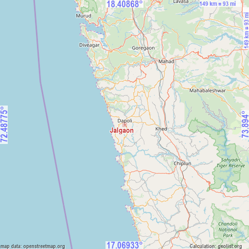
Jalgaon GPS coordinates[2]
17° 44' 24.936" North, 73° 11' 27.132" East
| Map corner | latitude | longitude |
|---|---|---|
| Upper-left | 18.40868°, | 72.48775° |
| Center: | 17.74026°, | 73.19087° |
| Lower-right: | 17.06933°, | 73.894° |
| Map W x H: | 148.9×148.9 km | = 92.5×92.5mi |
| max Lat: | 34.9274° ⇑72.3% North |
| Jalgaon: | 17.74026° |
| min Lat: | ⇓27.7% South 8.09008° |
| min Long | Jalgaon | max Long |
| 68.82655° | 73.19087° | 96.81° |
| W 6.2%⇐ | ⇒93.8% E |
Elevation
Elevation of Jalgaon is 177 m = 581 ft, and this is 118.6 m = 389 ft below average elevation for this country.
| Max E: |
3681 m = 12077 ft | 54.6% |
| Avg. | 295.6 m = 970 ft | |
| Jalgaon | 177 m = 581 ft | |
Min E: |
1 m = 3 ft | 45.4% |
See also: India elevation on elevation.city.
Geographical zone
Jalgaon is located in North Torrid zone (between Equator and Tropic of Cancer). Distance of this Northern Tropic circle is 633.4 km =393.6 mi to North.| Distance of | km | miles | from Jalgaon |
|---|---|---|---|
| North Pole | 8034.5 | 4992.4 | to North |
| Arctic Circle | 5428.6 | 3373.2 | to North |
| Tropic Cancer | 633.4 | 393.6 | to North |
| Equator | 1972.5 | 1225.7 | to South |


Nearby cities:
15 places around Jalgaon: (largest is in red/bold)
• Chiplūn
40.8 km =25.4 mi,  124°
124°
• Dābhol
16.8 km =10.4 mi,  183°
183°
• Goregaon
47.3 km =29.4 mi,  12°
12°
• Guhāgar
28.5 km =17.7 mi, 179°
• Harnai
12.9 km =8 mi,  309°
309°
• Indāpur
62.6 km =38.9 mi, 5°
• Khed
22 km =13.7 mi,  96°
96°
• Koynanagar
71.8 km =44.6 mi, 121°
• Mahābaleshwar
29.9 km =18.6 mi,  132°
132°
• Mahād
45 km =28 mi,  32°
32°
• Mhasla
44.5 km =27.7 mi,  349°
349°
• Murud
69.7 km =43.3 mi,  339°
339°
• Mākhjan
61.7 km =38.3 mi,  147°
147°
• Pānchgani
67.7 km =42.1 mi,  72°
72°
• Srīvardhan
38.7 km =24 mi,  331°
331°
Sources, notices
• [Note1] Compared only with cities in India existing in our database
• [Src1] Map data: © OpenStreetMap contributors (CC-BY-SA)
• [Src2] Other city data from geonames.org with taken over terms of usage.
• [Src3] Geographical zone / Annual Mean Temperature by Robert A. Rohde @ Wikipedia
