Khed geodata
Khed (Maharashtra) is a populated place; located in India in Asia/Kolkata (GMT+5.5) time zone. With population of 14,829 people, there are 2481 cities with bigger population in this country. Compared to other cities in India, 72.4% of cities are located further ↑North; 93% of cities are located further →East and 88.6% of cities have higher elevation than Khed. Note1


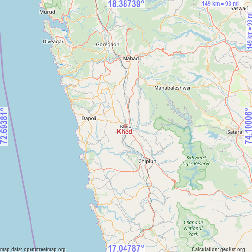
Khed GPS coordinates[2]
17° 43' 7.968" North, 73° 23' 48.948" East
| Map corner | latitude | longitude |
|---|---|---|
| Upper-left | 18.38739°, | 72.69381° |
| Center: | 17.71888°, | 73.39693° |
| Lower-right: | 17.04787°, | 74.10006° |
| Map W x H: | 148.9×148.9 km | = 92.5×92.5mi |
| max Lat: | 34.9274° ⇑72.4% North |
| Khed: | 17.71888° |
| min Lat: | ⇓27.6% South 8.09008° |
| min Long | Khed | max Long |
| 68.82655° | 73.39693° | 96.81° |
| W 7%⇐ | ⇒93% E |
Elevation
Elevation of Khed is 21 m = 69 ft, and this is 274.6 m = 901 ft below average elevation for this country.
| Max E: |
3681 m = 12077 ft | 88.6% |
| Avg. | 295.6 m = 970 ft | |
| Khed | 21 m = 69 ft | |
Min E: |
1 m = 3 ft | 11.4% |
See also: India elevation on elevation.city.
Geographical zone
Khed is located in North Torrid zone (between Equator and Tropic of Cancer). Distance of this Northern Tropic circle is 635.8 km =395.1 mi to North.| Distance of | km | miles | from Khed |
|---|---|---|---|
| North Pole | 8036.9 | 4993.9 | to North |
| Arctic Circle | 5431 | 3374.7 | to North |
| Tropic Cancer | 635.8 | 395.1 | to North |
| Equator | 1970.2 | 1224.2 | to South |


Nearby cities:
15 places around Khed: (largest is in red/bold)
• Chiplūn
23.8 km =14.8 mi,  149°
149°
• Dābhol
27.1 km =16.8 mi,  237°
237°
• Goregaon
49.7 km =30.9 mi,  347°
347°
• Guhāgar
33.9 km =21.1 mi,  219°
219°
• Harnai
33.5 km =20.8 mi,  288°
288°
• Jalgaon
22 km =13.7 mi,  276°
276°
• Koynanagar
52.9 km =32.9 mi,  132°
132°
• Mahābaleshwar
17.7 km =11 mi,  178°
178°
• Mahād
40.6 km =25.2 mi,  2°
2°
• Mhasla
55.1 km =34.2 mi,  326°
326°
• Mākhjan
51.1 km =31.8 mi,  167°
167°
• Pānchgani
48.5 km =30.1 mi,  61°
61°
• Satara
63.3 km =39.3 mi,  93°
93°
• Srīvardhan
54.3 km =33.7 mi,  312°
312°
• Wai
58.4 km =36.3 mi, 63°
Sources, notices
• [Note1] Compared only with cities in India existing in our database
• [Src1] Map data: © OpenStreetMap contributors (CC-BY-SA)
• [Src2] Other city data from geonames.org with taken over terms of usage.
• [Src3] Geographical zone / Annual Mean Temperature by Robert A. Rohde @ Wikipedia
