Lāsalgaon geodata
Lāsalgaon (Maharashtra) is a populated place; located in India in Asia/Kolkata (GMT+5.5) time zone. With population of 13,665 people, there are 2595 cities with bigger population in this country. Compared to other cities in India, 64.7% of cities are located further ↑North; 88.2% of cities are located further →East and 87.8% of cities have lower elevation than Lāsalgaon. Note1


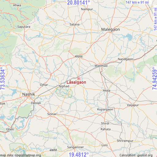
Lāsalgaon GPS coordinates[2]
20° 8' 33.72" North, 74° 14' 22.056" East
| Map corner | latitude | longitude |
|---|---|---|
| Upper-left | 20.80141°, | 73.53634° |
| Center: | 20.1427°, | 74.23946° |
| Lower-right: | 19.4812°, | 74.94259° |
| Map W x H: | 146.8×146.8 km | = 91.2×91.2mi |
| max Lat: | 34.9274° ⇑64.7% North |
| Lāsalgaon: | 20.1427° |
| min Lat: | ⇓35.3% South 8.09008° |
| min Long | Lāsalgaon | max Long |
| 68.82655° | 74.23946° | 96.81° |
| W 11.8%⇐ | ⇒88.2% E |
Elevation
Elevation of Lāsalgaon is 590 m = 1936 ft, and this is 294.4 m = 966 ft above average elevation for this country.
| Max E: |
3681 m = 12077 ft | 12.2% |
| Lāsalgaon | 590 m 1936 ft | |
| Avg. | 295.6 m = 970 ft | |
Min E: |
1 m = 3 ft | 87.8% |
See also: India elevation on elevation.city.
Geographical zone
Lāsalgaon is located in North Torrid zone (between Equator and Tropic of Cancer). Distance of this Northern Tropic circle is 366.3 km =227.6 mi to North.| Distance of | km | miles | from Lāsalgaon |
|---|---|---|---|
| North Pole | 7767.4 | 4826.4 | to North |
| Arctic Circle | 5161.5 | 3207.2 | to North |
| Tropic Cancer | 366.3 | 227.6 | to North |
| Equator | 2239.7 | 1391.7 | to South |


Nearby cities:
15 places around Lāsalgaon: (largest is in red/bold)
• Chāndor
20.9 km =13 mi,  1°
1°
• Deolāli
47.7 km =29.6 mi,  242°
242°
• Kopargaon
38.1 km =23.7 mi,  139°
139°
• Manmād
24.1 km =15 mi,  59°
59°
• Mālegaon
54.7 km =34 mi,  34°
34°
• Nashik
49.6 km =30.8 mi,  250°
250°
• Nāndgaon
47 km =29.2 mi,  67°
67°
• Ozar
32.9 km =20.4 mi,  260°
260°
• Sangamner
64 km =39.8 mi,  182°
182°
• Satānā
50.4 km =31.3 mi,  355°
355°
• Shirdi
48.7 km =30.3 mi,  149°
149°
• Sinnar
41.6 km =25.8 mi,  217°
217°
• Trimbak
77.8 km =48.3 mi, 252°
• Vaijāpur
56.4 km =35 mi,  115°
115°
• Yeola
28.4 km =17.6 mi,  113°
113°
Sources, notices
• [Note1] Compared only with cities in India existing in our database
• [Src1] Map data: © OpenStreetMap contributors (CC-BY-SA)
• [Src2] Other city data from geonames.org with taken over terms of usage.
• [Src3] Geographical zone / Annual Mean Temperature by Robert A. Rohde @ Wikipedia
