Yeola geodata
Yeola (Maharashtra) is a populated place; located in India in Asia/Kolkata (GMT+5.5) time zone. With population of 46,762 people, there are 946 cities with bigger population in this country. Compared to other cities in India, 65% of cities are located further ↑North; 86.8% of cities are located further →East and 86% of cities have lower elevation than Yeola. Note1


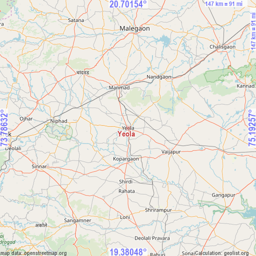
Yeola GPS coordinates[2]
20° 2' 32.64" North, 74° 29' 21.984" East
| Map corner | latitude | longitude |
|---|---|---|
| Upper-left | 20.70154°, | 73.78632° |
| Center: | 20.0424°, | 74.48944° |
| Lower-right: | 19.38048°, | 75.19257° |
| Map W x H: | 146.9×146.9 km | = 91.3×91.3mi |
| max Lat: | 34.9274° ⇑65% North |
| Yeola: | 20.0424° |
| min Lat: | ⇓35% South 8.09008° |
| min Long | Yeola | max Long |
| 68.82655° | 74.48944° | 96.81° |
| W 13.2%⇐ | ⇒86.8% E |
Elevation
Elevation of Yeola is 562 m = 1844 ft, and this is 266.4 m = 874 ft above average elevation for this country.
| Max E: |
3681 m = 12077 ft | 14% |
| Yeola | 562 m 1844 ft | |
| Avg. | 295.6 m = 970 ft | |
Min E: |
1 m = 3 ft | 86% |
See also: Yeola elevation on elevation.city.
Geographical zone
Yeola is located in North Torrid zone (between Equator and Tropic of Cancer). Distance of this Northern Tropic circle is 377.4 km =234.5 mi to North.| Distance of | km | miles | from Yeola |
|---|---|---|---|
| North Pole | 7778.6 | 4833.4 | to North |
| Arctic Circle | 5172.7 | 3214.2 | to North |
| Tropic Cancer | 377.4 | 234.5 | to North |
| Equator | 2228.5 | 1384.7 | to South |


Nearby cities:
15 places around Yeola: (largest is in red/bold)
• Chāndor
41 km =25.5 mi,  321°
321°
• Deolāli
69.3 km =43.1 mi,  260°
260°
• Ellora
70.4 km =43.7 mi,  91°
91°
• Gangāpur
66.6 km =41.4 mi,  125°
125°
• Kopargaon
17.8 km =11.1 mi,  184°
184°
• Lāsalgaon
28.4 km =17.6 mi,  293°
293°
• Manmād
24.1 km =15 mi,  346°
346°
• Mālegaon
56.6 km =35.2 mi,  4°
4°
• Nāndgaon
34.1 km =21.2 mi,  30°
30°
• Ozar
58.9 km =36.6 mi,  275°
275°
• Sangamner
60.2 km =37.4 mi,  208°
208°
• Satānā
68.3 km =42.4 mi,  334°
334°
• Shirdi
30.7 km =19.1 mi, 182°
• Sinnar
55.8 km =34.7 mi,  246°
246°
• Vaijāpur
28 km =17.4 mi,  117°
117°
Sources, notices
• [Note1] Compared only with cities in India existing in our database
• [Src1] Map data: © OpenStreetMap contributors (CC-BY-SA)
• [Src2] Other city data from geonames.org with taken over terms of usage.
• [Src3] Geographical zone / Annual Mean Temperature by Robert A. Rohde @ Wikipedia
