Satānā geodata
Satānā (Maharashtra) is a populated place; located in India in Asia/Kolkata (GMT+5.5) time zone. With population of 34,440 people, there are 1262 cities with bigger population in this country. Compared to other cities in India, 63.4% of cities are located further ↑North; 88.3% of cities are located further →East and 85.5% of cities have lower elevation than Satānā. Note1


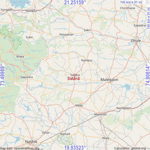
Satānā GPS coordinates[2]
20° 35' 41.388" North, 74° 12' 10.836" East
| Map corner | latitude | longitude |
|---|---|---|
| Upper-left | 21.25159°, | 73.49989° |
| Center: | 20.59483°, | 74.20301° |
| Lower-right: | 19.93523°, | 74.90614° |
| Map W x H: | 146.4×146.4 km | = 91×91mi |
| max Lat: | 34.9274° ⇑63.4% North |
| Satānā: | 20.59483° |
| min Lat: | ⇓36.6% South 8.09008° |
| min Long | Satānā | max Long |
| 68.82655° | 74.20301° | 96.81° |
| W 11.7%⇐ | ⇒88.3% E |
Elevation
Elevation of Satānā is 557 m = 1827 ft, and this is 261.4 m = 858 ft above average elevation for this country.
| Max E: |
3681 m = 12077 ft | 14.5% |
| Satānā | 557 m 1827 ft | |
| Avg. | 295.6 m = 970 ft | |
Min E: |
1 m = 3 ft | 85.5% |
See also: India elevation on elevation.city.
Geographical zone
Satānā is located in North Torrid zone (between Equator and Tropic of Cancer). Distance of this Northern Tropic circle is 316 km =196.4 mi to North.| Distance of | km | miles | from Satānā |
|---|---|---|---|
| North Pole | 7717.1 | 4795.2 | to North |
| Arctic Circle | 5111.2 | 3176 | to North |
| Tropic Cancer | 316 | 196.4 | to North |
| Equator | 2289.9 | 1422.9 | to South |


Nearby cities:
15 places around Satānā: (largest is in red/bold)
• Ahwa
56.7 km =35.2 mi,  288°
288°
• Chāndor
29.7 km =18.5 mi,  171°
171°
• Deolāli
81.9 km =50.9 mi,  207°
207°
• Dhūlia
68.8 km =42.8 mi,  60°
60°
• Kopargaon
84.2 km =52.3 mi,  160°
160°
• Lāsalgaon
50.4 km =31.3 mi,  175°
175°
• Manmād
45.2 km =28.1 mi,  147°
147°
• Mālegaon
34.9 km =21.7 mi,  98°
98°
• Nandurbar
85.9 km =53.4 mi,  2°
2°
• Nashik
79.1 km =49.2 mi, 212°
• Nāndgaon
56.9 km =35.4 mi,  124°
124°
• Ozar
62.6 km =38.9 mi, 207°
• Surgāna
59 km =36.7 mi,  266°
266°
• Waghāi
75.6 km =47 mi,  284°
284°
• Yeola
68.3 km =42.4 mi, 154°
Sources, notices
• [Note1] Compared only with cities in India existing in our database
• [Src1] Map data: © OpenStreetMap contributors (CC-BY-SA)
• [Src2] Other city data from geonames.org with taken over terms of usage.
• [Src3] Geographical zone / Annual Mean Temperature by Robert A. Rohde @ Wikipedia
