Chāndor geodata
Chāndor (Maharashtra) is a populated place; located in India in Asia/Kolkata (GMT+5.5) time zone. With population of 19,592 people, there are 2069 cities with bigger population in this country. Compared to other cities in India, 64.1% of cities are located further ↑North; 88.1% of cities are located further →East and 92.8% of cities have lower elevation than Chāndor. Note1


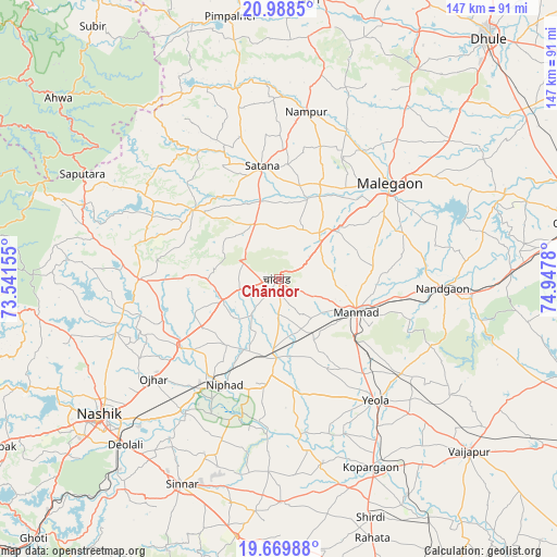
Chāndor GPS coordinates[2]
20° 19' 50.16" North, 74° 14' 40.812" East
| Map corner | latitude | longitude |
|---|---|---|
| Upper-left | 20.9885°, | 73.54155° |
| Center: | 20.3306°, | 74.24467° |
| Lower-right: | 19.66988°, | 74.9478° |
| Map W x H: | 146.6×146.6 km | = 91.1×91.1mi |
| max Lat: | 34.9274° ⇑64.1% North |
| Chāndor: | 20.3306° |
| min Lat: | ⇓35.9% South 8.09008° |
| min Long | Chāndor | max Long |
| 68.82655° | 74.24467° | 96.81° |
| W 11.9%⇐ | ⇒88.1% E |
Elevation
Elevation of Chāndor is 734 m = 2408 ft, and this is 438.4 m = 1438 ft above average elevation for this country.
| Max E: |
3681 m = 12077 ft | 7.2% |
| Chāndor | 734 m 2408 ft | |
| Avg. | 295.6 m = 970 ft | |
Min E: |
1 m = 3 ft | 92.8% |
See also: India elevation on elevation.city.
Geographical zone
Chāndor is located in North Torrid zone (between Equator and Tropic of Cancer). Distance of this Northern Tropic circle is 345.4 km =214.6 mi to North.| Distance of | km | miles | from Chāndor |
|---|---|---|---|
| North Pole | 7746.5 | 4813.5 | to North |
| Arctic Circle | 5140.6 | 3194.2 | to North |
| Tropic Cancer | 345.4 | 214.6 | to North |
| Equator | 2260.6 | 1404.7 | to South |


Nearby cities:
15 places around Chāndor: (largest is in red/bold)
• Ahwa
75 km =46.6 mi,  309°
309°
• Deolāli
60.7 km =37.7 mi,  224°
224°
• Kopargaon
55.4 km =34.4 mi,  154°
154°
• Lāsalgaon
20.9 km =13 mi,  181°
181°
• Manmād
21.9 km =13.6 mi,  113°
113°
• Mālegaon
38.8 km =24.1 mi,  51°
51°
• Nashik
60.1 km =37.3 mi,  231°
231°
• Nāndgaon
42.9 km =26.7 mi,  93°
93°
• Ozar
42.2 km =26.2 mi, 231°
• Satānā
29.7 km =18.5 mi,  351°
351°
• Shirdi
67.3 km =41.8 mi,  158°
158°
• Sinnar
59.8 km =37.2 mi,  205°
205°
• Surgāna
68.2 km =42.4 mi,  291°
291°
• Vaijāpur
67.5 km =41.9 mi,  131°
131°
• Yeola
41 km =25.5 mi,  141°
141°
Sources, notices
• [Note1] Compared only with cities in India existing in our database
• [Src1] Map data: © OpenStreetMap contributors (CC-BY-SA)
• [Src2] Other city data from geonames.org with taken over terms of usage.
• [Src3] Geographical zone / Annual Mean Temperature by Robert A. Rohde @ Wikipedia
