Kopargaon geodata
Kopargaon (Maharashtra) is a populated place; located in India in Asia/Kolkata (GMT+5.5) time zone. With population of 65,116 people, there are 673 cities with bigger population in this country. Compared to other cities in India, 65.7% of cities are located further ↑North; 87% of cities are located further →East and 82.9% of cities have lower elevation than Kopargaon. Note1


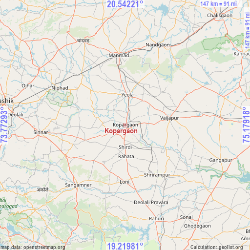
Kopargaon GPS coordinates[2]
19° 52' 56.604" North, 74° 28' 33.78" East
| Map corner | latitude | longitude |
|---|---|---|
| Upper-left | 20.54221°, | 73.77293° |
| Center: | 19.88239°, | 74.47605° |
| Lower-right: | 19.21981°, | 75.17918° |
| Map W x H: | 147×147 km | = 91.3×91.3mi |
| max Lat: | 34.9274° ⇑65.7% North |
| Kopargaon: | 19.88239° |
| min Lat: | ⇓34.3% South 8.09008° |
| min Long | Kopargaon | max Long |
| 68.82655° | 74.47605° | 96.81° |
| W 13%⇐ | ⇒87% E |
Elevation
Elevation of Kopargaon is 504 m = 1654 ft, and this is 208.4 m = 684 ft above average elevation for this country.
| Max E: |
3681 m = 12077 ft | 17.1% |
| Kopargaon | 504 m 1654 ft | |
| Avg. | 295.6 m = 970 ft | |
Min E: |
1 m = 3 ft | 82.9% |
See also: Kopargaon elevation on elevation.city.
Geographical zone
Kopargaon is located in North Torrid zone (between Equator and Tropic of Cancer). Distance of this Northern Tropic circle is 395.2 km =245.6 mi to North.| Distance of | km | miles | from Kopargaon |
|---|---|---|---|
| North Pole | 7796.3 | 4844.4 | to North |
| Arctic Circle | 5190.5 | 3225.2 | to North |
| Tropic Cancer | 395.2 | 245.6 | to North |
| Equator | 2210.7 | 1373.7 | to South |


Nearby cities:
15 places around Kopargaon: (largest is in red/bold)
• Chāndor
55.4 km =34.4 mi,  334°
334°
• Deolāli
67.4 km =41.9 mi,  275°
275°
• Ellora
73.5 km =45.7 mi,  77°
77°
• Gangāpur
59.6 km =37 mi,  110°
110°
• Lāsalgaon
38.1 km =23.7 mi,  319°
319°
• Manmād
41.4 km =25.7 mi,  354°
354°
• Nashik
72.7 km =45.2 mi, 280°
• Nāndgaon
50.8 km =31.6 mi,  21°
21°
• Ozar
61.9 km =38.5 mi,  292°
292°
• Rāhuri
57.6 km =35.8 mi,  161°
161°
• Sangamner
44.6 km =27.7 mi,  218°
218°
• Shirdi
12.9 km =8 mi,  179°
179°
• Sinnar
50.1 km =31.1 mi,  265°
265°
• Vaijāpur
26.7 km =16.6 mi, 79°
• Yeola
17.8 km =11.1 mi,  4°
4°
Sources, notices
• [Note1] Compared only with cities in India existing in our database
• [Src1] Map data: © OpenStreetMap contributors (CC-BY-SA)
• [Src2] Other city data from geonames.org with taken over terms of usage.
• [Src3] Geographical zone / Annual Mean Temperature by Robert A. Rohde @ Wikipedia
