Nāndgaon geodata
Nāndgaon (Maharashtra) is a populated place; located in India in Asia/Kolkata (GMT+5.5) time zone. With population of 24,209 people, there are 1755 cities with bigger population in this country. Compared to other cities in India, 64.2% of cities are located further ↑North; 85.6% of cities are located further →East and 81.5% of cities have lower elevation than Nāndgaon. Note1


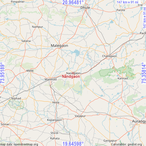
Nāndgaon GPS coordinates[2]
20° 18' 24.48" North, 74° 39' 18.036" East
| Map corner | latitude | longitude |
|---|---|---|
| Upper-left | 20.96481°, | 73.95189° |
| Center: | 20.3068°, | 74.65501° |
| Lower-right: | 19.64598°, | 75.35814° |
| Map W x H: | 146.6×146.6 km | = 91.1×91.1mi |
| max Lat: | 34.9274° ⇑64.2% North |
| Nāndgaon: | 20.3068° |
| min Lat: | ⇓35.8% South 8.09008° |
| min Long | Nāndgaon | max Long |
| 68.82655° | 74.65501° | 96.81° |
| W 14.4%⇐ | ⇒85.6% E |
Elevation
Elevation of Nāndgaon is 480 m = 1575 ft, and this is 184.4 m = 605 ft above average elevation for this country.
| Max E: |
3681 m = 12077 ft | 18.5% |
| Nāndgaon | 480 m 1575 ft | |
| Avg. | 295.6 m = 970 ft | |
Min E: |
1 m = 3 ft | 81.5% |
See also: India elevation on elevation.city.
Geographical zone
Nāndgaon is located in North Torrid zone (between Equator and Tropic of Cancer). Distance of this Northern Tropic circle is 348 km =216.2 mi to North.| Distance of | km | miles | from Nāndgaon |
|---|---|---|---|
| North Pole | 7749.2 | 4815.1 | to North |
| Arctic Circle | 5143.3 | 3195.9 | to North |
| Tropic Cancer | 348 | 216.2 | to North |
| Equator | 2257.9 | 1403 | to South |


Nearby cities:
15 places around Nāndgaon: (largest is in red/bold)
• Chālisgaon
41.2 km =25.6 mi,  65°
65°
• Chāndor
42.9 km =26.7 mi,  273°
273°
• Daulatābād
72.1 km =44.8 mi,  124°
124°
• Dhūlia
67.3 km =41.8 mi,  10°
10°
• Ellora
61.7 km =38.3 mi, 120°
• Kannad
50.7 km =31.5 mi,  96°
96°
• Khuldābād
65.3 km =40.6 mi, 120°
• Kopargaon
50.8 km =31.6 mi,  201°
201°
• Lāsalgaon
47 km =29.2 mi,  247°
247°
• Manmād
23.4 km =14.5 mi,  255°
255°
• Mālegaon
29.8 km =18.5 mi,  335°
335°
• Satānā
56.9 km =35.4 mi,  304°
304°
• Shirdi
62.9 km =39.1 mi, 197°
• Vaijāpur
42.9 km =26.7 mi,  169°
169°
• Yeola
34.1 km =21.2 mi,  210°
210°
Sources, notices
• [Note1] Compared only with cities in India existing in our database
• [Src1] Map data: © OpenStreetMap contributors (CC-BY-SA)
• [Src2] Other city data from geonames.org with taken over terms of usage.
• [Src3] Geographical zone / Annual Mean Temperature by Robert A. Rohde @ Wikipedia
