Pendra geodata
Pendra (Chhattisgarh) is a populated place; located in India in Asia/Kolkata (GMT+5.5) time zone. With population of 12,637 people, there are 2688 cities with bigger population in this country. Compared to other cities in India, 50.1% of cities are located further ↑North; 76.4% of cities are located further ←West and 89% of cities have lower elevation than Pendra. Note1


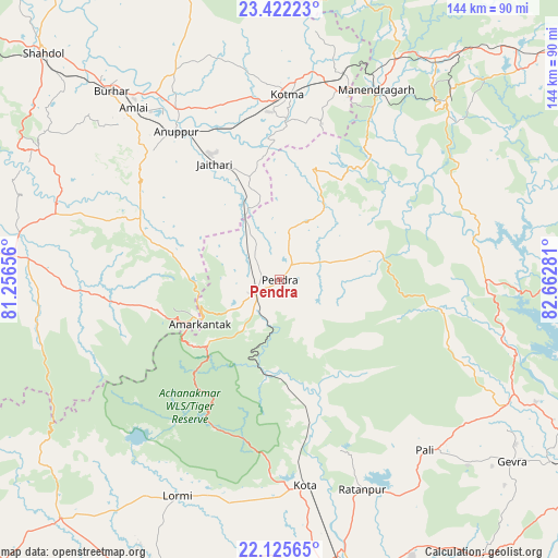
Pendra GPS coordinates[2]
22° 46' 31.728" North, 81° 57' 34.848" East
| Map corner | latitude | longitude |
|---|---|---|
| Upper-left | 23.42223°, | 81.25656° |
| Center: | 22.77548°, | 81.95968° |
| Lower-right: | 22.12565°, | 82.66281° |
| Map W x H: | 144.2×144.2 km | = 89.6×89.6mi |
| max Lat: | 34.9274° ⇑50.1% North |
| Pendra: | 22.77548° |
| min Lat: | ⇓49.9% South 8.09008° |
| min Long | Pendra | max Long |
| 68.82655° | 81.95968° | 96.81° |
| W 76.4%⇐ | ⇒23.6% E |
Elevation
Elevation of Pendra is 613 m = 2011 ft, and this is 317.4 m = 1041 ft above average elevation for this country.
| Max E: |
3681 m = 12077 ft | 11% |
| Pendra | 613 m 2011 ft | |
| Avg. | 295.6 m = 970 ft | |
Min E: |
1 m = 3 ft | 89% |
See also: India elevation on elevation.city.
Geographical zone
Pendra is located in North Torrid zone (between Equator and Tropic of Cancer). Distance of this Northern Tropic circle is 73.5 km =45.7 mi to North.| Distance of | km | miles | from Pendra |
|---|---|---|---|
| North Pole | 7474.7 | 4644.6 | to North |
| Arctic Circle | 4868.8 | 3025.3 | to North |
| Tropic Cancer | 73.5 | 45.7 | to North |
| Equator | 2532.4 | 1573.6 | to South |


Nearby cities:
15 places around Pendra: (largest is in red/bold)
• Amarkantak
23.4 km =14.5 mi,  241°
241°
• Anūppur
45.7 km =28.4 mi,  322°
322°
• Baikunthpur
81.9 km =50.9 mi,  48°
48°
• Bilāspur
79.9 km =49.6 mi,  165°
165°
• Bodri
69.2 km =43 mi,  308°
308°
• Burhar
65.6 km =40.8 mi, 318°
• Gaurela
6.4 km =4 mi,  248°
248°
• Katghora
67.1 km =41.7 mi,  116°
116°
• Kotma
47.7 km =29.6 mi,  2°
2°
• Kotā
53.8 km =33.4 mi, 172°
• Lormi
61.7 km =38.3 mi,  205°
205°
• Pandaria
83.3 km =51.8 mi,  222°
222°
• Pasān
25.6 km =15.9 mi,  72°
72°
• Ratanpur
58.4 km =36.3 mi,  158°
158°
• Takhatpur
72.5 km =45 mi,  187°
187°
Sources, notices
• [Note1] Compared only with cities in India existing in our database
• [Src1] Map data: © OpenStreetMap contributors (CC-BY-SA)
• [Src2] Other city data from geonames.org with taken over terms of usage.
• [Src3] Geographical zone / Annual Mean Temperature by Robert A. Rohde @ Wikipedia
