Gaurela geodata
Gaurela (Chhattisgarh) is a populated place; located in India in Asia/Kolkata (GMT+5.5) time zone. With population of 14,582 people, there are 2504 cities with bigger population in this country. Compared to other cities in India, 50.3% of cities are located further ↑North; 76.2% of cities are located further ←West and 89.4% of cities have lower elevation than Gaurela. Note1


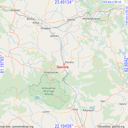
Gaurela GPS coordinates[2]
22° 45' 16.164" North, 81° 54' 3.852" East
| Map corner | latitude | longitude |
|---|---|---|
| Upper-left | 23.40134°, | 81.19795° |
| Center: | 22.75449°, | 81.90107° |
| Lower-right: | 22.10456°, | 82.6042° |
| Map W x H: | 144.2×144.2 km | = 89.6×89.6mi |
| max Lat: | 34.9274° ⇑50.3% North |
| Gaurela: | 22.75449° |
| min Lat: | ⇓49.7% South 8.09008° |
| min Long | Gaurela | max Long |
| 68.82655° | 81.90107° | 96.81° |
| W 76.2%⇐ | ⇒23.8% E |
Elevation
Elevation of Gaurela is 622 m = 2041 ft, and this is 326.4 m = 1071 ft above average elevation for this country.
| Max E: |
3681 m = 12077 ft | 10.6% |
| Gaurela | 622 m 2041 ft | |
| Avg. | 295.6 m = 970 ft | |
Min E: |
1 m = 3 ft | 89.4% |
See also: India elevation on elevation.city.
Geographical zone
Gaurela is located in North Torrid zone (between Equator and Tropic of Cancer). Distance of this Northern Tropic circle is 75.9 km =47.2 mi to North.| Distance of | km | miles | from Gaurela |
|---|---|---|---|
| North Pole | 7477 | 4646 | to North |
| Arctic Circle | 4871.1 | 3026.8 | to North |
| Tropic Cancer | 75.9 | 47.2 | to North |
| Equator | 2530.1 | 1572.1 | to South |


Nearby cities:
15 places around Gaurela: (largest is in red/bold)
• Amarkantak
17 km =10.6 mi,  238°
238°
• Anūppur
44.4 km =27.6 mi,  330°
330°
• Bilāspur
79.4 km =49.3 mi,  160°
160°
• Bodri
66.2 km =41.1 mi,  313°
313°
• Burhar
63.6 km =39.5 mi,  323°
323°
• Katghora
71.6 km =44.5 mi,  113°
113°
• Kotma
50.6 km =31.4 mi,  9°
9°
• Kotā
52.6 km =32.7 mi,  166°
166°
• Lormi
57.2 km =35.5 mi,  200°
200°
• Mungeli
79.7 km =49.5 mi, 196°
• Pandaria
77.5 km =48.2 mi,  220°
220°
• Pasān
32 km =19.9 mi,  71°
71°
• Pendra
6.4 km =4 mi, 68°
• Ratanpur
58.8 km =36.5 mi,  152°
152°
• Takhatpur
69.6 km =43.2 mi,  182°
182°
Sources, notices
• [Note1] Compared only with cities in India existing in our database
• [Src1] Map data: © OpenStreetMap contributors (CC-BY-SA)
• [Src2] Other city data from geonames.org with taken over terms of usage.
• [Src3] Geographical zone / Annual Mean Temperature by Robert A. Rohde @ Wikipedia
