Katghora geodata
Katghora (Chhattisgarh) is a populated place; located in India in Asia/Kolkata (GMT+5.5) time zone. With population of 20,113 people, there are 2031 cities with bigger population in this country. Compared to other cities in India, 53.1% of cities are located further ↑North; 77.9% of cities are located further ←West and 69.7% of cities have lower elevation than Katghora. Note1


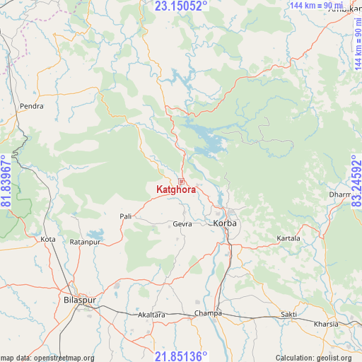
Katghora GPS coordinates[2]
22° 30' 8.892" North, 82° 32' 34.044" East
| Map corner | latitude | longitude |
|---|---|---|
| Upper-left | 23.15052°, | 81.83967° |
| Center: | 22.50247°, | 82.54279° |
| Lower-right: | 21.85136°, | 83.24592° |
| Map W x H: | 144.5×144.5 km | = 89.8×89.8mi |
| max Lat: | 34.9274° ⇑53.1% North |
| Katghora: | 22.50247° |
| min Lat: | ⇓46.9% South 8.09008° |
| min Long | Katghora | max Long |
| 68.82655° | 82.54279° | 96.81° |
| W 77.9%⇐ | ⇒22.1% E |
Elevation
Elevation of Katghora is 325 m = 1066 ft, and this is 29.4 m = 96 ft above average elevation for this country.
| Max E: |
3681 m = 12077 ft | 30.3% |
| Katghora | 325 m 1066 ft | |
| Avg. | 295.6 m = 970 ft | |
Min E: |
1 m = 3 ft | 69.7% |
See also: India elevation on elevation.city.
Geographical zone
Katghora is located in North Torrid zone (between Equator and Tropic of Cancer). Distance of this Northern Tropic circle is 103.9 km =64.6 mi to North.| Distance of | km | miles | from Katghora |
|---|---|---|---|
| North Pole | 7505 | 4663.4 | to North |
| Arctic Circle | 4899.1 | 3044.2 | to North |
| Tropic Cancer | 103.9 | 64.6 | to North |
| Equator | 2502 | 1554.7 | to South |


Nearby cities:
15 places around Katghora: (largest is in red/bold)
• Akaltara
54.5 km =33.9 mi,  192°
192°
• Amarkantak
82.7 km =51.4 mi,  283°
283°
• Baloda
40.9 km =25.4 mi, 188°
• Bilāspur
61.6 km =38.3 mi,  220°
220°
• Chāmpa
52.9 km =32.9 mi,  168°
168°
• Gaurela
71.6 km =44.5 mi,  293°
293°
• Jānjgīr
55 km =34.2 mi,  176°
176°
• Kharsia
81.2 km =50.5 mi,  134°
134°
• Korba
23.5 km =14.6 mi,  137°
137°
• Kotā
58.1 km =36.1 mi,  246°
246°
• Pasān
51.9 km =32.2 mi,  317°
317°
• Pendra
67.1 km =41.7 mi,  296°
296°
• Ratanpur
45.4 km =28.2 mi,  238°
238°
• Saktī
68.2 km =42.4 mi, 140°
• Takhatpur
80.7 km =50.1 mi, 239°
Sources, notices
• [Note1] Compared only with cities in India existing in our database
• [Src1] Map data: © OpenStreetMap contributors (CC-BY-SA)
• [Src2] Other city data from geonames.org with taken over terms of usage.
• [Src3] Geographical zone / Annual Mean Temperature by Robert A. Rohde @ Wikipedia
