Pasān geodata
Pasān (Chhattisgarh) is a populated place; located in India in Asia/Kolkata (GMT+5.5) time zone. With population of 30,928 people, there are 1405 cities with bigger population in this country. Compared to other cities in India, 50.5% of cities are located further ↓South; 77.3% of cities are located further ←West and 84.2% of cities have lower elevation than Pasān. Note1


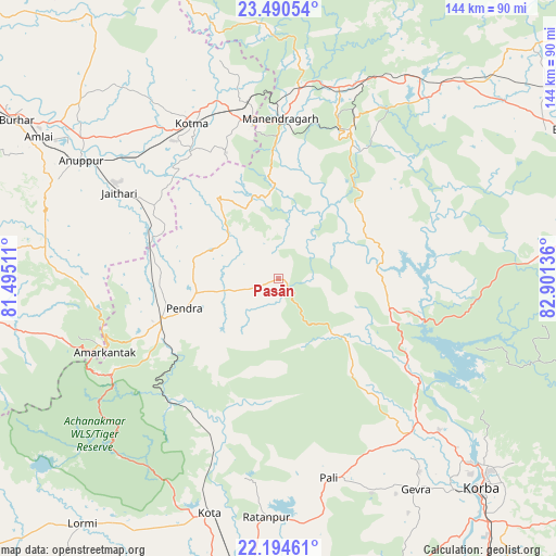
Pasān GPS coordinates[2]
22° 50' 38.832" North, 82° 11' 53.628" East
| Map corner | latitude | longitude |
|---|---|---|
| Upper-left | 23.49054°, | 81.49511° |
| Center: | 22.84412°, | 82.19823° |
| Lower-right: | 22.19461°, | 82.90136° |
| Map W x H: | 144.1×144.1 km | = 89.5×89.5mi |
| max Lat: | 34.9274° ⇑49.5% North |
| Pasān: | 22.84412° |
| min Lat: | ⇓50.5% South 8.09008° |
| min Long | Pasān | max Long |
| 68.82655° | 82.19823° | 96.81° |
| W 77.3%⇐ | ⇒22.7% E |
Elevation
Elevation of Pasān is 536 m = 1759 ft, and this is 240.4 m = 789 ft above average elevation for this country.
| Max E: |
3681 m = 12077 ft | 15.8% |
| Pasān | 536 m 1759 ft | |
| Avg. | 295.6 m = 970 ft | |
Min E: |
1 m = 3 ft | 84.2% |
See also: India elevation on elevation.city.
Geographical zone
Pasān is located in North Torrid zone (between Equator and Tropic of Cancer). Distance of this Northern Tropic circle is 65.9 km =40.9 mi to North.| Distance of | km | miles | from Pasān |
|---|---|---|---|
| North Pole | 7467 | 4639.8 | to North |
| Arctic Circle | 4861.1 | 3020.5 | to North |
| Tropic Cancer | 65.9 | 40.9 | to North |
| Equator | 2540 | 1578.3 | to South |


Nearby cities:
15 places around Pasān: (largest is in red/bold)
• Amarkantak
48.8 km =30.3 mi,  247°
247°
• Anūppur
59.4 km =36.9 mi,  299°
299°
• Baikunthpur
59.4 km =36.9 mi,  38°
38°
• Baloda
83.6 km =51.9 mi,  159°
159°
• Bilāspur
85.1 km =52.9 mi,  182°
182°
• Burhar
79.7 km =49.5 mi, 301°
• Gaurela
32 km =19.9 mi, 251°
• Katghora
51.9 km =32.2 mi,  137°
137°
• Korba
75.4 km =46.9 mi, 137°
• Kotma
45.9 km =28.5 mi,  330°
330°
• Kotā
63.6 km =39.5 mi,  196°
196°
• Lormi
81.3 km =50.5 mi,  218°
218°
• Pendra
25.6 km =15.9 mi, 252°
• Ratanpur
62.1 km =38.6 mi, 182°
• Surajpur
79.9 km =49.6 mi,  59°
59°
Sources, notices
• [Note1] Compared only with cities in India existing in our database
• [Src1] Map data: © OpenStreetMap contributors (CC-BY-SA)
• [Src2] Other city data from geonames.org with taken over terms of usage.
• [Src3] Geographical zone / Annual Mean Temperature by Robert A. Rohde @ Wikipedia
