Sīra geodata
Sīra (Karnataka) is a populated place; located in India in Asia/Kolkata (GMT+5.5) time zone. With population of 57,928 people, there are 759 cities with bigger population in this country. Compared to other cities in India, 83.7% of cities are located further ↑North; 64.4% of cities are located further →East and 91% of cities have lower elevation than Sīra. Note1


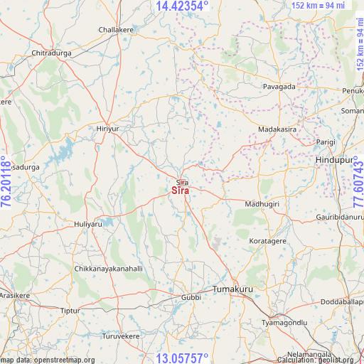
Sīra GPS coordinates[2]
13° 44' 29.58" North, 76° 54' 15.48" East
| Map corner | latitude | longitude |
|---|---|---|
| Upper-left | 14.42354°, | 76.20118° |
| Center: | 13.74155°, | 76.9043° |
| Lower-right: | 13.05757°, | 77.60743° |
| Map W x H: | 151.9×151.9 km | = 94.4×94.4mi |
| max Lat: | 34.9274° ⇑83.7% North |
| Sīra: | 13.74155° |
| min Lat: | ⇓16.3% South 8.09008° |
| min Long | Sīra | max Long |
| 68.82655° | 76.9043° | 96.81° |
| W 35.6%⇐ | ⇒64.4% E |
Elevation
Elevation of Sīra is 654 m = 2146 ft, and this is 358.4 m = 1176 ft above average elevation for this country.
| Max E: |
3681 m = 12077 ft | 9% |
| Sīra | 654 m 2146 ft | |
| Avg. | 295.6 m = 970 ft | |
Min E: |
1 m = 3 ft | 91% |
See also: Sīra elevation on elevation.city.
Geographical zone
Sīra is located in North Torrid zone (between Equator and Tropic of Cancer). Distance of this Northern Tropic circle is 1078 km =669.8 mi to North.| Distance of | km | miles | from Sīra |
|---|---|---|---|
| North Pole | 8479.1 | 5268.7 | to North |
| Arctic Circle | 5873.3 | 3649.5 | to North |
| Tropic Cancer | 1078 | 669.8 | to North |
| Equator | 1527.9 | 949.4 | to South |


Nearby cities:
15 places around Sīra: (largest is in red/bold)
• Challakere
69.6 km =43.2 mi,  336°
336°
• Chiknāyakanhalli
47.4 km =29.5 mi,  220°
220°
• Goribidnūr
67.8 km =42.1 mi,  102°
102°
• Gubbi
47.9 km =29.8 mi,  175°
175°
• Hindupur
64.1 km =39.8 mi,  81°
81°
• Hiriyūr
38.3 km =23.8 mi,  306°
306°
• Hosakote
65.9 km =40.9 mi,  25°
25°
• Hosdurga
67.3 km =41.8 mi,  275°
275°
• Kodigenahalli
52.1 km =32.4 mi,  92°
92°
• Koratagere
43.5 km =27 mi,  124°
124°
• Maddagiri
34.5 km =21.4 mi,  105°
105°
• Pāvugada
56.8 km =35.3 mi,  45°
45°
• Tiptūr
71 km =44.1 mi, 220°
• Tumkūr
49.4 km =30.7 mi,  154°
154°
• Turuvekere
69.2 km =43 mi,  201°
201°
Sources, notices
• [Note1] Compared only with cities in India existing in our database
• [Src1] Map data: © OpenStreetMap contributors (CC-BY-SA)
• [Src2] Other city data from geonames.org with taken over terms of usage.
• [Src3] Geographical zone / Annual Mean Temperature by Robert A. Rohde @ Wikipedia
