Gubbi geodata
Gubbi (Karnataka) is a populated place; located in India in Asia/Kolkata (GMT+5.5) time zone. With population of 17,983 people, there are 2201 cities with bigger population in this country. Compared to other cities in India, 85% of cities are located further ↑North; 63.8% of cities are located further →East and 93.8% of cities have lower elevation than Gubbi. Note1


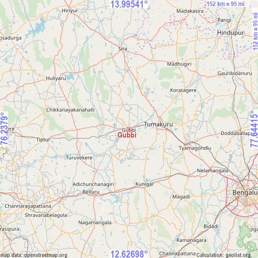
Gubbi GPS coordinates[2]
13° 18' 43.776" North, 76° 56' 27.672" East
| Map corner | latitude | longitude |
|---|---|---|
| Upper-left | 13.99541°, | 76.2379° |
| Center: | 13.31216°, | 76.94102° |
| Lower-right: | 12.62698°, | 77.64415° |
| Map W x H: | 152.2×152.2 km | = 94.6×94.6mi |
| max Lat: | 34.9274° ⇑85% North |
| Gubbi: | 13.31216° |
| min Lat: | ⇓15% South 8.09008° |
| min Long | Gubbi | max Long |
| 68.82655° | 76.94102° | 96.81° |
| W 36.2%⇐ | ⇒63.8% E |
Elevation
Elevation of Gubbi is 786 m = 2579 ft, and this is 490.4 m = 1609 ft above average elevation for this country.
| Max E: |
3681 m = 12077 ft | 6.2% |
| Gubbi | 786 m 2579 ft | |
| Avg. | 295.6 m = 970 ft | |
Min E: |
1 m = 3 ft | 93.8% |
See also: India elevation on elevation.city.
Geographical zone
Gubbi is located in North Torrid zone (between Equator and Tropic of Cancer). Distance of this Northern Tropic circle is 1125.7 km =699.5 mi to North.| Distance of | km | miles | from Gubbi |
|---|---|---|---|
| North Pole | 8526.9 | 5298.4 | to North |
| Arctic Circle | 5921 | 3679.1 | to North |
| Tropic Cancer | 1125.7 | 699.5 | to North |
| Equator | 1480.2 | 919.8 | to South |


Nearby cities:
15 places around Gubbi: (largest is in red/bold)
• Bellūru
43.1 km =26.8 mi,  211°
211°
• Chiknāyakanhalli
36.5 km =22.7 mi,  288°
288°
• Dod Ballāpur
64.6 km =40.1 mi,  91°
91°
• Kodigenahalli
66.2 km =41.1 mi,  46°
46°
• Koratagere
39.6 km =24.6 mi, 53°
• Kunigal
33.4 km =20.8 mi,  164°
164°
• Maddagiri
48.6 km =30.2 mi,  37°
37°
• Māgadi
50 km =31.1 mi,  142°
142°
• Nelamangala
54.4 km =33.8 mi,  115°
115°
• Nāgamangala
58.4 km =36.3 mi,  200°
200°
• Srāvana Belgola
70.4 km =43.7 mi,  224°
224°
• Sīra
47.9 km =29.8 mi,  355°
355°
• Tiptūr
50.5 km =31.4 mi,  262°
262°
• Tumkūr
17.7 km =11 mi,  79°
79°
• Turuvekere
34 km =21.1 mi,  240°
240°
Sources, notices
• [Note1] Compared only with cities in India existing in our database
• [Src1] Map data: © OpenStreetMap contributors (CC-BY-SA)
• [Src2] Other city data from geonames.org with taken over terms of usage.
• [Src3] Geographical zone / Annual Mean Temperature by Robert A. Rohde @ Wikipedia
