Dinapore geodata
Dinapore (Bihar) is a populated place; located in India in Asia/Kolkata (GMT+5.5) time zone. With population of 152,940 people, there are 287 cities with bigger population in this country. Compared to other cities in India, 67.9% of cities are located further ↓South; 84.4% of cities are located further ←West and 77% of cities have higher elevation than Dinapore. Note1


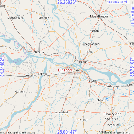
Dinapore GPS coordinates[2]
25° 38' 13.38" North, 85° 2' 52.584" East
| Map corner | latitude | longitude |
|---|---|---|
| Upper-left | 26.26926°, | 84.34482° |
| Center: | 25.63705°, | 85.04794° |
| Lower-right: | 25.00147°, | 85.75107° |
| Map W x H: | 141×141 km | = 87.6×87.6mi |
| max Lat: | 34.9274° ⇑32.1% North |
| Dinapore: | 25.63705° |
| min Lat: | ⇓67.9% South 8.09008° |
| min Long | Dinapore | max Long |
| 68.82655° | 85.04794° | 96.81° |
| W 84.4%⇐ | ⇒15.6% E |
Elevation
Elevation of Dinapore is 59 m = 194 ft, and this is 236.6 m = 776 ft below average elevation for this country.
| Max E: |
3681 m = 12077 ft | 77% |
| Avg. | 295.6 m = 970 ft | |
| Dinapore | 59 m = 194 ft | |
Min E: |
1 m = 3 ft | 23% |
See also: Dinapore elevation on elevation.city.
Geographical zone
Dinapore is located in North temperate zone (between Tropic of Cancer and the Arctic Circle). Distance of this Northern Tropic circle is 244.7 km =152 mi to South.| Distance of | km | miles | from Dinapore |
|---|---|---|---|
| North Pole | 7156.5 | 4446.8 | to North |
| Arctic Circle | 4550.6 | 2827.6 | to North |
| Tropic Cancer | 244.7 | 152 | to South |
| Equator | 2850.6 | 1771.3 | to South |


Nearby cities:
15 places around Dinapore: (largest is in red/bold)
• Arrah
39.6 km =24.6 mi,  256°
256°
• Chāpra
34.1 km =21.2 mi,  297°
297°
• Dighwāra
12.5 km =7.8 mi,  342°
342°
• Fatwa
29.4 km =18.3 mi,  118°
118°
• Hilsa
42.7 km =26.5 mi,  146°
146°
• Hājīpur
17.1 km =10.6 mi,  71°
71°
• Khagaul
6.5 km =4 mi,  182°
182°
• Khusropur
38 km =23.6 mi, 117°
• Koelwār
25.9 km =16.1 mi, 255°
• Lālganj
28.7 km =17.8 mi,  26°
26°
• Maner
17.6 km =10.9 mi,  273°
273°
• Marhaura
41.5 km =25.8 mi,  334°
334°
• Masaurhi Buzurg
31.5 km =19.6 mi, 182°
• Patna
10 km =6.2 mi, 118°
• Revelganj
44.6 km =27.7 mi,  292°
292°
Sources, notices
• [Note1] Compared only with cities in India existing in our database
• [Src1] Map data: © OpenStreetMap contributors (CC-BY-SA)
• [Src2] Other city data from geonames.org with taken over terms of usage.
• [Src3] Geographical zone / Annual Mean Temperature by Robert A. Rohde @ Wikipedia
