Masaurhi Buzurg geodata
Masaurhi Buzurg (Bihar) is a populated place; located in India in Asia/Kolkata (GMT+5.5) time zone. With population of 53,440 people, there are 830 cities with bigger population in this country. Compared to other cities in India, 65.7% of cities are located further ↓South; 84.3% of cities are located further ←West and 76.3% of cities have higher elevation than Masaurhi Buzurg. Note1


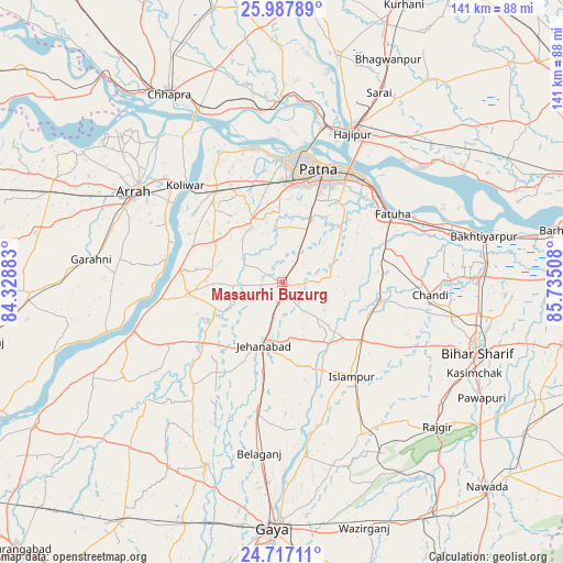
Masaurhi Buzurg GPS coordinates[2]
25° 21' 15.012" North, 85° 1' 55.02" East
| Map corner | latitude | longitude |
|---|---|---|
| Upper-left | 25.98789°, | 84.32883° |
| Center: | 25.35417°, | 85.03195° |
| Lower-right: | 24.71711°, | 85.73508° |
| Map W x H: | 141.3×141.3 km | = 87.8×87.8mi |
| max Lat: | 34.9274° ⇑34.3% North |
| Masaurhi Buzurg: | 25.35417° |
| min Lat: | ⇓65.7% South 8.09008° |
| min Long | Masaurhi Buzurg | max Long |
| 68.82655° | 85.03195° | 96.81° |
| W 84.3%⇐ | ⇒15.7% E |
Elevation
Elevation of Masaurhi Buzurg is 62 m = 203 ft, and this is 233.6 m = 766 ft below average elevation for this country.
| Max E: |
3681 m = 12077 ft | 76.3% |
| Avg. | 295.6 m = 970 ft | |
| Masaurhi Buzurg | 62 m = 203 ft | |
Min E: |
1 m = 3 ft | 23.7% |
See also: Masaurhi Buzurg elevation on elevation.city.
Geographical zone
Masaurhi Buzurg is located in North temperate zone (between Tropic of Cancer and the Arctic Circle). Distance of this Northern Tropic circle is 213.2 km =132.5 mi to South.| Distance of | km | miles | from Masaurhi Buzurg |
|---|---|---|---|
| North Pole | 7187.9 | 4466.4 | to North |
| Arctic Circle | 4582.1 | 2847.2 | to North |
| Tropic Cancer | 213.2 | 132.5 | to South |
| Equator | 2819.1 | 1751.7 | to South |


Nearby cities:
15 places around Masaurhi Buzurg: (largest is in red/bold)
• Arrah
43.3 km =26.9 mi,  301°
301°
• Dighwāra
43.4 km =27 mi,  357°
357°
• Dinapore
31.5 km =19.6 mi,  2°
2°
• Fatwa
32.4 km =20.1 mi,  57°
57°
• Hilsa
25.5 km =15.8 mi,  99°
99°
• Hājīpur
40.9 km =25.4 mi,  25°
25°
• Islāmpur
29.5 km =18.3 mi,  143°
143°
• Jahānābād
16.3 km =10.1 mi,  196°
196°
• Khagaul
25 km =15.5 mi, 3°
• Khusropur
38.2 km =23.7 mi,  68°
68°
• Koelwār
34.5 km =21.4 mi,  316°
316°
• Maner
36.2 km =22.5 mi,  333°
333°
• Patna
28.6 km =17.8 mi,  21°
21°
• Silao
49.9 km =31 mi,  127°
127°
• Tekāri
49.6 km =30.8 mi, 202°
Sources, notices
• [Note1] Compared only with cities in India existing in our database
• [Src1] Map data: © OpenStreetMap contributors (CC-BY-SA)
• [Src2] Other city data from geonames.org with taken over terms of usage.
• [Src3] Geographical zone / Annual Mean Temperature by Robert A. Rohde @ Wikipedia
