Dighwāra geodata
Dighwāra (Bihar) is a populated place; located in India in Asia/Kolkata (GMT+5.5) time zone. With population of 29,270 people, there are 1481 cities with bigger population in this country. Compared to other cities in India, 68.7% of cities are located further ↓South; 84.3% of cities are located further ←West and 77% of cities have higher elevation than Dighwāra. Note1


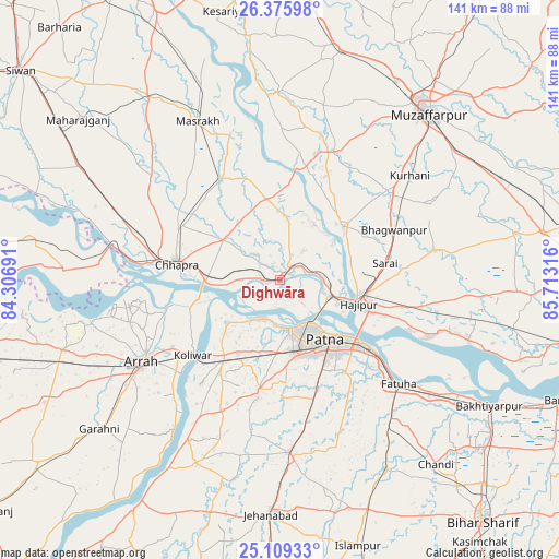
Dighwāra GPS coordinates[2]
25° 44' 39.624" North, 85° 0' 36.108" East
| Map corner | latitude | longitude |
|---|---|---|
| Upper-left | 26.37598°, | 84.30691° |
| Center: | 25.74434°, | 85.01003° |
| Lower-right: | 25.10933°, | 85.71316° |
| Map W x H: | 140.8×140.8 km | = 87.5×87.5mi |
| max Lat: | 34.9274° ⇑31.3% North |
| Dighwāra: | 25.74434° |
| min Lat: | ⇓68.7% South 8.09008° |
| min Long | Dighwāra | max Long |
| 68.82655° | 85.01003° | 96.81° |
| W 84.3%⇐ | ⇒15.7% E |
Elevation
Elevation of Dighwāra is 59 m = 194 ft, and this is 236.6 m = 776 ft below average elevation for this country.
| Max E: |
3681 m = 12077 ft | 77% |
| Avg. | 295.6 m = 970 ft | |
| Dighwāra | 59 m = 194 ft | |
Min E: |
1 m = 3 ft | 23% |
See also: India elevation on elevation.city.
Geographical zone
Dighwāra is located in North temperate zone (between Tropic of Cancer and the Arctic Circle). Distance of this Northern Tropic circle is 256.6 km =159.4 mi to South.| Distance of | km | miles | from Dighwāra |
|---|---|---|---|
| North Pole | 7144.6 | 4439.4 | to North |
| Arctic Circle | 4538.7 | 2820.2 | to North |
| Tropic Cancer | 256.6 | 159.4 | to South |
| Equator | 2862.5 | 1778.7 | to South |


Nearby cities:
15 places around Dighwāra: (largest is in red/bold)
• Arrah
40.6 km =25.2 mi,  238°
238°
• Chāpra
26.6 km =16.5 mi,  278°
278°
• Dinapore
12.5 km =7.8 mi,  162°
162°
• Fatwa
39.4 km =24.5 mi,  131°
131°
• Hilsa
54.9 km =34.1 mi,  150°
150°
• Hājīpur
21.1 km =13.1 mi,  108°
108°
• Khagaul
18.7 km =11.6 mi,  169°
169°
• Khusropur
47.6 km =29.6 mi, 127°
• Koelwār
28 km =17.4 mi,  229°
229°
• Lālganj
21.5 km =13.4 mi,  49°
49°
• Maner
17.6 km =10.9 mi, 231°
• Marhaura
29.2 km =18.1 mi,  330°
330°
• Masaurhi Buzurg
43.4 km =27 mi,  177°
177°
• Patna
20.9 km =13 mi,  143°
143°
• Revelganj
37.8 km =23.5 mi, 277°
Sources, notices
• [Note1] Compared only with cities in India existing in our database
• [Src1] Map data: © OpenStreetMap contributors (CC-BY-SA)
• [Src2] Other city data from geonames.org with taken over terms of usage.
• [Src3] Geographical zone / Annual Mean Temperature by Robert A. Rohde @ Wikipedia
