Khurai geodata
Khurai (Madhya Pradesh) is a populated place; located in India in Asia/Kolkata (GMT+5.5) time zone. With population of 31,613 people, there are 1372 cities with bigger population in this country. Compared to other cities in India, 58.4% of cities are located further ↓South; 52.5% of cities are located further ←West and 78.5% of cities have lower elevation than Khurai. Note1


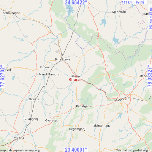
Khurai GPS coordinates[2]
24° 2' 37.392" North, 78° 19' 48.504" East
| Map corner | latitude | longitude |
|---|---|---|
| Upper-left | 24.68422°, | 77.62702° |
| Center: | 24.04372°, | 78.33014° |
| Lower-right: | 23.40001°, | 79.03327° |
| Map W x H: | 142.8×142.8 km | = 88.7×88.7mi |
| max Lat: | 34.9274° ⇑41.6% North |
| Khurai: | 24.04372° |
| min Lat: | ⇓58.4% South 8.09008° |
| min Long | Khurai | max Long |
| 68.82655° | 78.33014° | 96.81° |
| W 52.5%⇐ | ⇒47.5% E |
Elevation
Elevation of Khurai is 439 m = 1440 ft, and this is 143.4 m = 470 ft above average elevation for this country.
| Max E: |
3681 m = 12077 ft | 21.5% |
| Khurai | 439 m 1440 ft | |
| Avg. | 295.6 m = 970 ft | |
Min E: |
1 m = 3 ft | 78.5% |
See also: India elevation on elevation.city.
Geographical zone
Khurai is located in North temperate zone (between Tropic of Cancer and the Arctic Circle). Distance of this Northern Tropic circle is 67.5 km =41.9 mi to South.| Distance of | km | miles | from Khurai |
|---|---|---|---|
| North Pole | 7333.7 | 4556.9 | to North |
| Arctic Circle | 4727.8 | 2937.7 | to North |
| Tropic Cancer | 67.5 | 41.9 | to South |
| Equator | 2673.4 | 1661.2 | to South |


Nearby cities:
15 places around Khurai: (largest is in red/bold)
• Bamora
24.5 km =15.2 mi,  273°
273°
• Banda
64.1 km =39.8 mi,  89°
89°
• Begamganj
49.4 km =30.7 mi,  178°
178°
• Bāsoda
45.3 km =28.1 mi,  241°
241°
• Dhāna
63.4 km =39.4 mi,  121°
121°
• Etāwa
20.2 km =12.6 mi,  320°
320°
• Karrāpur
55.4 km =34.4 mi,  100°
100°
• Korwai
30.6 km =19 mi,  285°
285°
• Lalitpur
72.4 km =45 mi,  7°
7°
• Mahroni
72.5 km =45 mi,  33°
33°
• Mungaoli
47 km =29.2 mi,  329°
329°
• Pāli
50.6 km =31.4 mi, 9°
• Rāhatgarh
29 km =18 mi,  166°
166°
• Saugor
47.4 km =29.5 mi, 118°
• Sironj
65.3 km =40.6 mi,  275°
275°
Sources, notices
• [Note1] Compared only with cities in India existing in our database
• [Src1] Map data: © OpenStreetMap contributors (CC-BY-SA)
• [Src2] Other city data from geonames.org with taken over terms of usage.
• [Src3] Geographical zone / Annual Mean Temperature by Robert A. Rohde @ Wikipedia
