Etāwa geodata
Etāwa (Madhya Pradesh) is a populated place; located in India in Asia/Kolkata (GMT+5.5) time zone. With population of 55,185 people, there are 806 cities with bigger population in this country. Compared to other cities in India, 58.9% of cities are located further ↓South; 51.1% of cities are located further ←West and 76.9% of cities have lower elevation than Etāwa. Note1


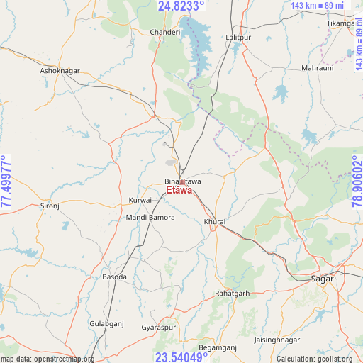
Etāwa GPS coordinates[2]
24° 11' 0.636" North, 78° 12' 10.404" East
| Map corner | latitude | longitude |
|---|---|---|
| Upper-left | 24.8233°, | 77.49977° |
| Center: | 24.18351°, | 78.20289° |
| Lower-right: | 23.54049°, | 78.90602° |
| Map W x H: | 142.6×142.6 km | = 88.6×88.6mi |
| max Lat: | 34.9274° ⇑41.1% North |
| Etāwa: | 24.18351° |
| min Lat: | ⇓58.9% South 8.09008° |
| min Long | Etāwa | max Long |
| 68.82655° | 78.20289° | 96.81° |
| W 51.1%⇐ | ⇒48.9% E |
Elevation
Elevation of Etāwa is 414 m = 1358 ft, and this is 118.4 m = 388 ft above average elevation for this country.
| Max E: |
3681 m = 12077 ft | 23.1% |
| Etāwa | 414 m 1358 ft | |
| Avg. | 295.6 m = 970 ft | |
Min E: |
1 m = 3 ft | 76.9% |
See also: Etāwa elevation on elevation.city.
Geographical zone
Etāwa is located in North temperate zone (between Tropic of Cancer and the Arctic Circle). Distance of this Northern Tropic circle is 83 km =51.6 mi to South.| Distance of | km | miles | from Etāwa |
|---|---|---|---|
| North Pole | 7318.1 | 4547.3 | to North |
| Arctic Circle | 4712.2 | 2928 | to North |
| Tropic Cancer | 83 | 51.6 | to South |
| Equator | 2689 | 1670.9 | to South |


Nearby cities:
15 places around Etāwa: (largest is in red/bold)
• Ashoknagar
64.7 km =40.2 mi,  312°
312°
• Bamora
18.3 km =11.4 mi,  218°
218°
• Begamganj
66.5 km =41.3 mi,  167°
167°
• Bāsoda
45.8 km =28.5 mi, 216°
• Chanderi
59.3 km =36.8 mi,  353°
353°
• Karrāpur
72.2 km =44.9 mi,  111°
111°
• Khurai
20.2 km =12.6 mi,  140°
140°
• Korwai
18.1 km =11.2 mi,  246°
246°
• Lalitpur
60.4 km =37.5 mi,  21°
21°
• Mahroni
69.5 km =43.2 mi,  49°
49°
• Mungaoli
27.3 km =17 mi,  336°
336°
• Pāli
40.5 km =25.2 mi,  32°
32°
• Rāhatgarh
47.9 km =29.8 mi,  156°
156°
• Saugor
66.6 km =41.4 mi,  125°
125°
• Sironj
52.7 km =32.7 mi,  260°
260°
Sources, notices
• [Note1] Compared only with cities in India existing in our database
• [Src1] Map data: © OpenStreetMap contributors (CC-BY-SA)
• [Src2] Other city data from geonames.org with taken over terms of usage.
• [Src3] Geographical zone / Annual Mean Temperature by Robert A. Rohde @ Wikipedia
