Sironj geodata
Sironj (Madhya Pradesh) is a populated place; located in India in Asia/Kolkata (GMT+5.5) time zone. With population of 45,455 people, there are 973 cities with bigger population in this country. Compared to other cities in India, 58.6% of cities are located further ↓South; 55.2% of cities are located further →East and 80.9% of cities have lower elevation than Sironj. Note1


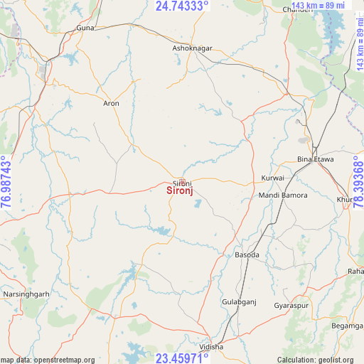
Sironj GPS coordinates[2]
24° 6' 11.268" North, 77° 41' 25.98" East
| Map corner | latitude | longitude |
|---|---|---|
| Upper-left | 24.74333°, | 76.98743° |
| Center: | 24.10313°, | 77.69055° |
| Lower-right: | 23.45971°, | 78.39368° |
| Map W x H: | 142.7×142.7 km | = 88.7×88.7mi |
| max Lat: | 34.9274° ⇑41.4% North |
| Sironj: | 24.10313° |
| min Lat: | ⇓58.6% South 8.09008° |
| min Long | Sironj | max Long |
| 68.82655° | 77.69055° | 96.81° |
| W 44.8%⇐ | ⇒55.2% E |
Elevation
Elevation of Sironj is 472 m = 1549 ft, and this is 176.4 m = 579 ft above average elevation for this country.
| Max E: |
3681 m = 12077 ft | 19.1% |
| Sironj | 472 m 1549 ft | |
| Avg. | 295.6 m = 970 ft | |
Min E: |
1 m = 3 ft | 80.9% |
See also: Sironj elevation on elevation.city.
Geographical zone
Sironj is located in North temperate zone (between Tropic of Cancer and the Arctic Circle). Distance of this Northern Tropic circle is 74.1 km =46 mi to South.| Distance of | km | miles | from Sironj |
|---|---|---|---|
| North Pole | 7327 | 4552.8 | to North |
| Arctic Circle | 4721.2 | 2933.6 | to North |
| Tropic Cancer | 74.1 | 46 | to South |
| Equator | 2680 | 1665.3 | to South |


Nearby cities:
15 places around Sironj: (largest is in red/bold)
• Ashoknagar
52.7 km =32.7 mi,  4°
4°
• Bamora
40.8 km =25.4 mi,  97°
97°
• Berasia
58.6 km =36.4 mi,  206°
206°
• Bāsoda
37.5 km =23.3 mi,  138°
138°
• Chandpura
48.7 km =30.3 mi,  235°
235°
• Etāwa
52.7 km =32.7 mi,  80°
80°
• Garha Brahman
42.7 km =26.5 mi,  232°
232°
• Khata Khedi
48.1 km =29.9 mi, 237°
• Khurai
65.3 km =40.6 mi, 95°
• Korwai
35.5 km =22.1 mi,  87°
87°
• Leteri
29 km =18 mi,  260°
260°
• Mungaoli
53.3 km =33.1 mi,  50°
50°
• Patalpani
44.9 km =27.9 mi, 229°
• Rāghogarh
62.7 km =39 mi,  307°
307°
• Āron
41.5 km =25.8 mi,  318°
318°
Sources, notices
• [Note1] Compared only with cities in India existing in our database
• [Src1] Map data: © OpenStreetMap contributors (CC-BY-SA)
• [Src2] Other city data from geonames.org with taken over terms of usage.
• [Src3] Geographical zone / Annual Mean Temperature by Robert A. Rohde @ Wikipedia
